There are many scenic waterways to kayak in the northern lower peninsula. I could spend a lifetime doing so and still not visit them all. These are a few of the lakes and rivers that I have paddled. Some are well known and others are off the beaten path. Not all of them are suitable for beginners and inexperienced kayakers. I could run out of adjectives describing the scenic beauty of each location. Take time to go “up north” and you’ll see what I mean!
The following is a list of northern lower peninsula destinations in the order in which they appear:
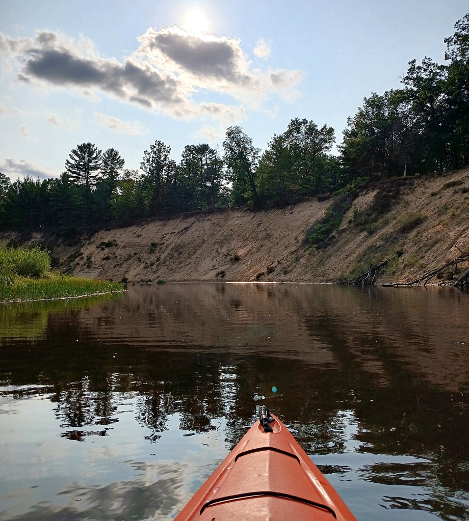
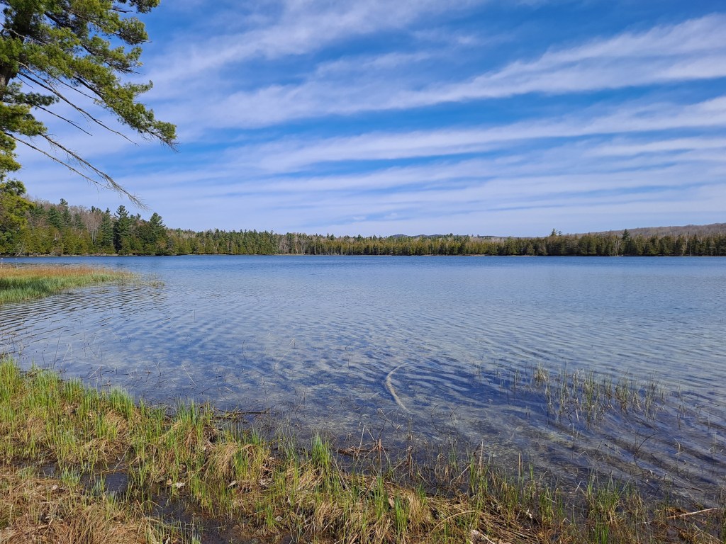
Muskegon River, Missaukee County
Muskegon River, Roscommon and Clare Counties
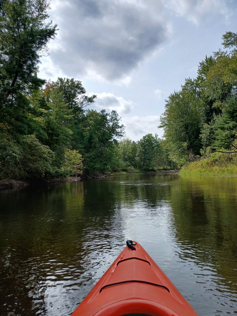
Au Sable River Mainstream, Crawford County
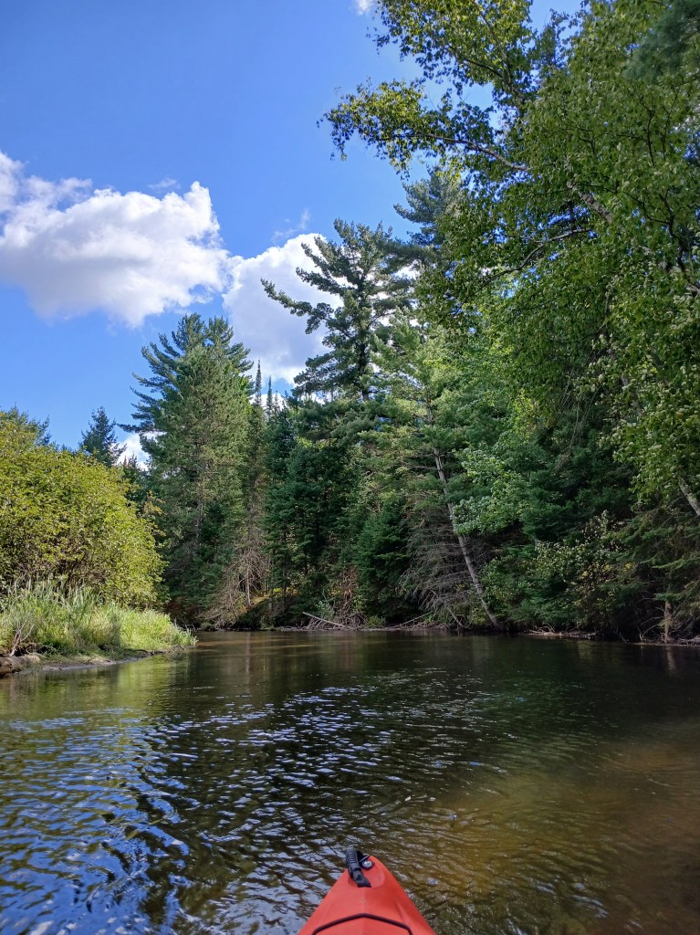
South Branch Au Sable River, Crawford County
Sturgeon River, Cheboygan County
Lake Michigan, Emmet County
Lake Huron, Cheboygan County
Ludington Area, Mason County
Sleeping Bear Dunes National Lakeshore, Benzie and Leelanau Counties
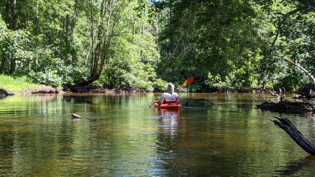
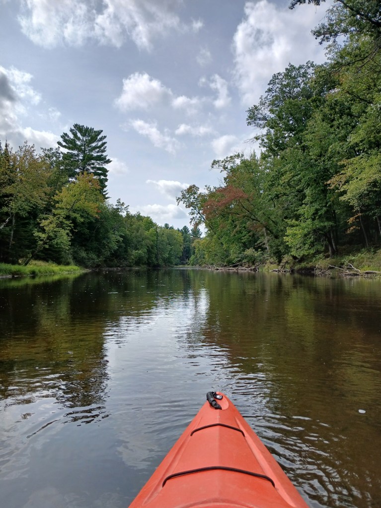
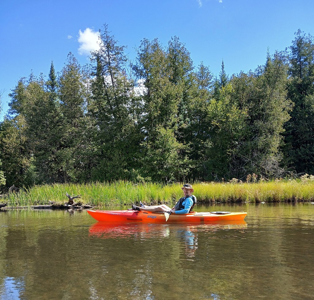
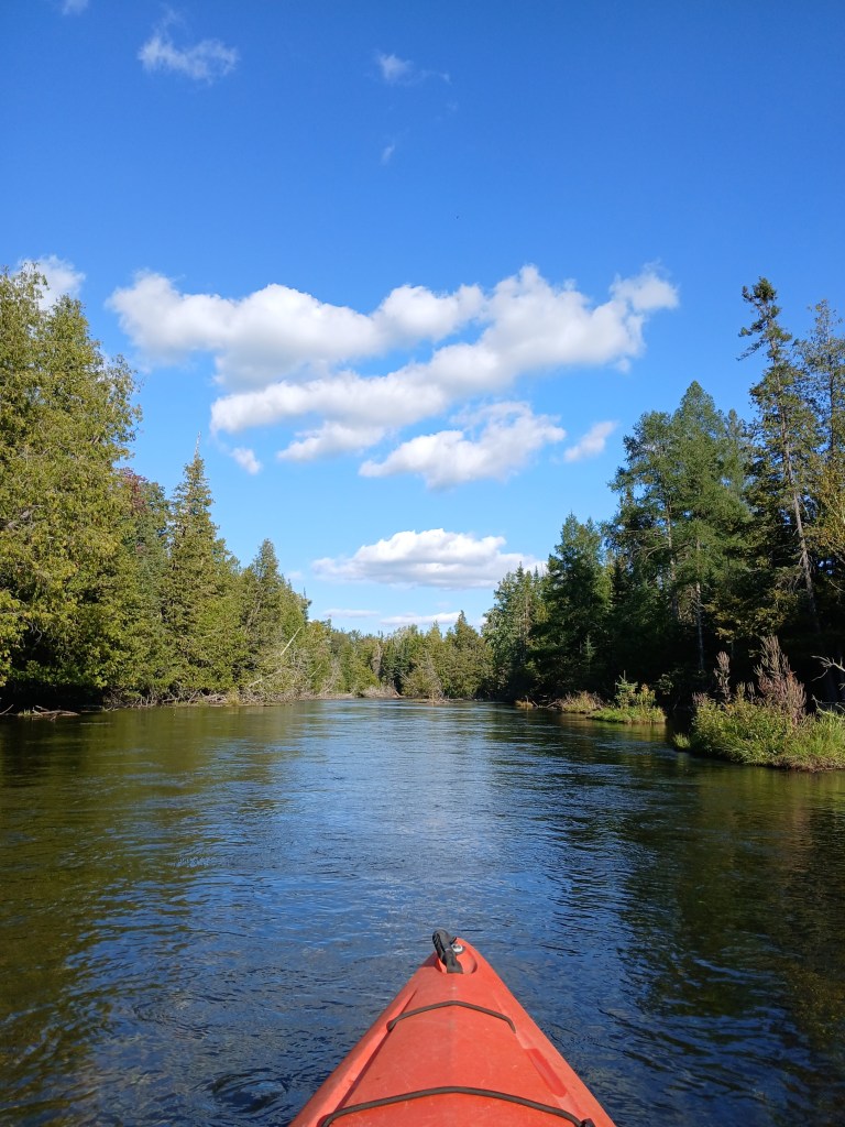
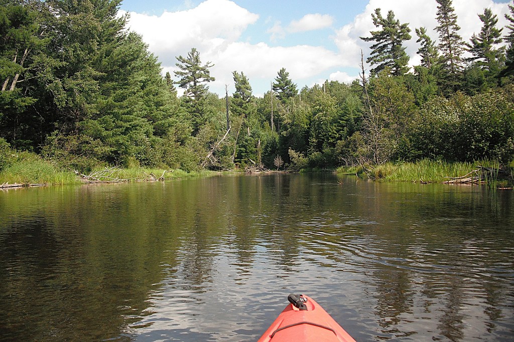
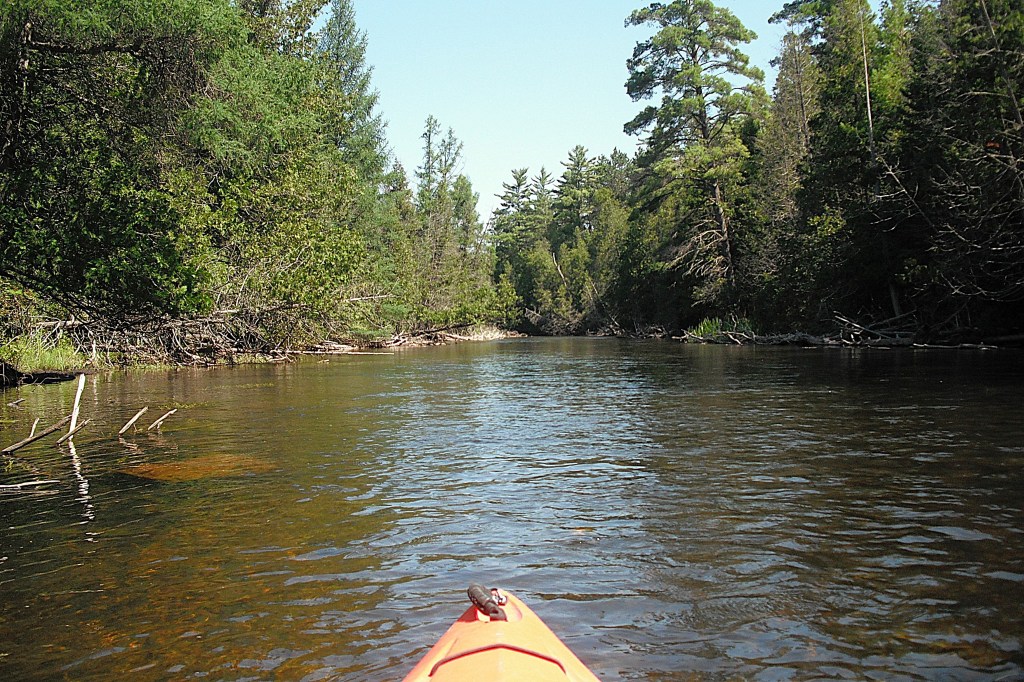
With a length of 216 miles, the Muskegon is the second longest river in Michigan. The Muskegon River watershed is a whopping 2350 square miles. The source of the Muskegon is the 20,000 acre Houghton Lake in Roscommon County.
My friend Dan and I decided to kayak a stretch of the Muskegon that is fairly close to the headwaters.
We began our voyage in Missaukee County at Porter Ranch, downstream from M55, off Jeffs Road. We used White Birch Campground for shuttle service. We ended our trip at White Birch, just upstream from the Cadillac Road bridge.
The upper Muskegon River is narrow and shallow: thirty feet wide and one to three feet deep. The bottom is pretty much all sand. The current is slow.
The riverbanks are populated primarily by hardwoods with a few stands of pine here and there.
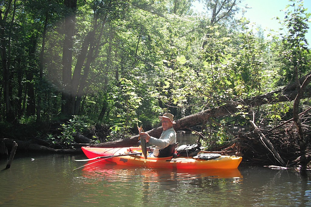
Dan showcased his angling skills by catching several pike!
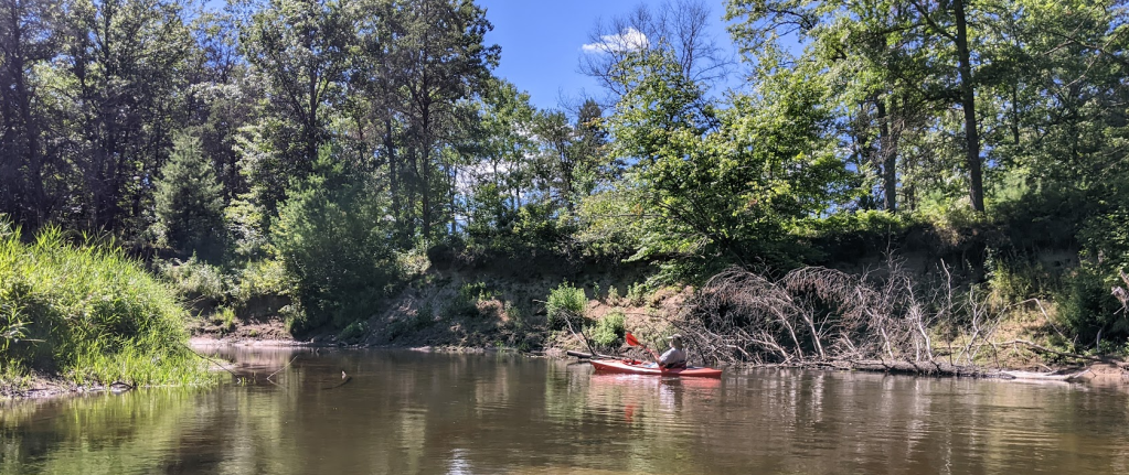
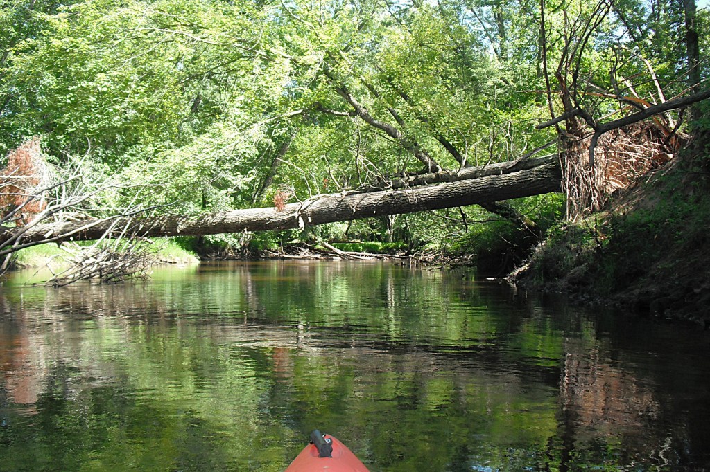
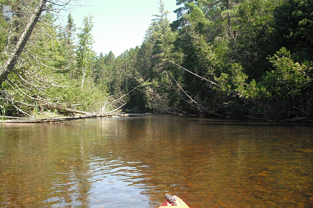
It sounds like the ideal easy kayak trip. It’s not! The river is loaded with fallen trees.
Here I am, getting back in my kayak after a portage.
We paddled over, under, and around many of the downed trees. Some had to be portaged by climbing over the trees and dragging our kayaks behind us. We had to get up on shore and carry our boats around trees only a couple times. It wasn’t all work. There were open places between sections of fallen trees.
Be careful when wading during portages. In many places, the sand bottom is not hard packed. A couple of times, I sunk into the loose sand halfway to my knees. It felt like I wasn’t going to stop sinking. Don’t stand still, keep moving!
We didn’t hear or see anybody while we were on the river. There were no homes or cabins on the shore and no roads were close to the river. It felt like wilderness even though we knew that it wasn’t.
We were tired when we arrived at White Birch, but we felt good. The river challenged us and we came out on top. It was a memorable trip for both of us. I encourage you to try it!
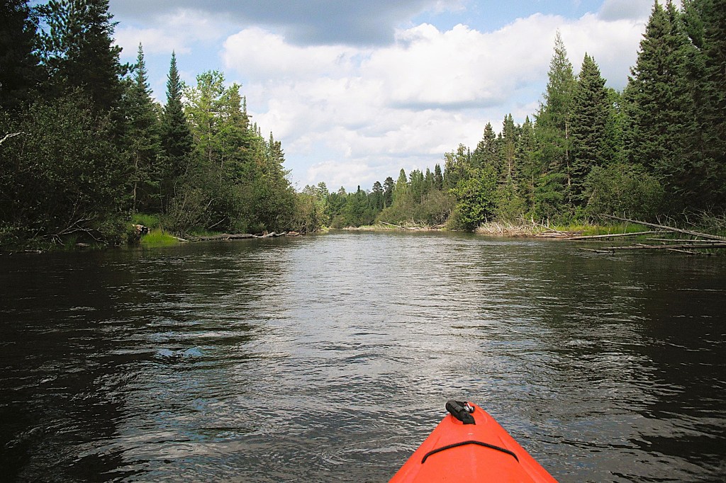
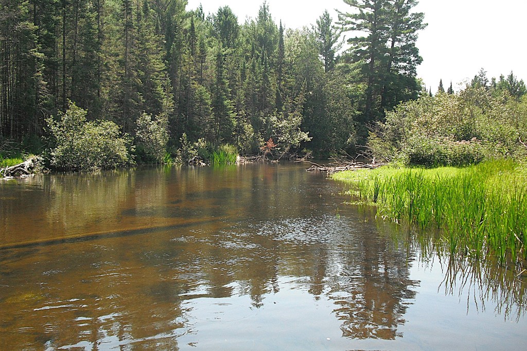
The Muskegon River flows through the Pere Marquette State Forest and the Au Sable State Forest from its source at Houghton Lake. This stretch of the river is south of M55, west of US127, and north of M61. I teamed up with my friend Dan on this trip. The river was at summer low water level. The river may be entirely different to kayak during high water levels.
Canoe Camp One is on Wexford Drive in Roscommon County. The orientation of the roads in this area can make driving confusing at times. The best way to find the camp is with GPS or Google Maps. A compass is always handy.
When you arrive at the camp, you will be surprised to find that there is no camp, just a clearing in the woods and some ORV trails. The clearing is visible on Google Maps satellite photos. A tall sand hill overlooks the river. A washout on the side of the hill provides river access.
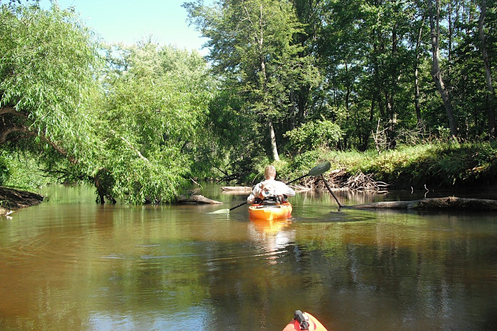
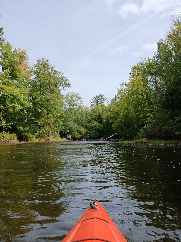
On the first part of the voyage, the current is moderate over a gravel and rock bottom. Large rocks and small boulders are scattered about. In some places, the rocks have created riffles with swift current. Some of the riffles could be technically classified as Class I rapids, but I thought that they were mild and easy to negotiate. In other words, don’t be concerned. Basic paddling skills will suffice.
We encountered a few fallen trees on this first stretch of the Muskegon, but not very many.
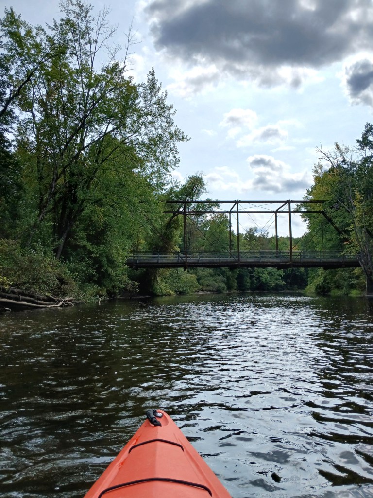
The Jonesville Bridge spans the river towards the end of the trip. The bridge is over a hundred years old and is limited to ATV, UTV, and dirt bike traffic only. The Leota ORV Trailhead is next to the bridge. We did not see or hear any off-road vehicles on our trip.
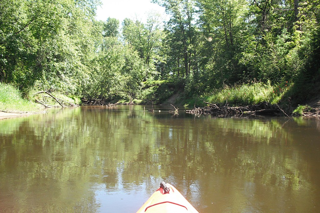
Downstream from the Jonesville Bridge, the current slows and the bottom changes from gravel and rock to sand. On the day of our trip, there were a lot of fallen trees in the river. Our kayaking skills were tested. We had to portage trees several times, so be prepared.
Four Story Banks is a tall steep sand hill that rises up from the river’s edge.
The voyage ends at the Hiram Abif Park on Muskegon Road in the Clare County community of Leota. The park is on the north side of the bridge and on the west side of the river. The park features picnic tables and a port-a-john, but the boat landing isn’t the best.
The Leota Pit Stop has great take-out pizza. The Trails End Pub in Leota is a good choice for food and drink. Here’s one last look at the river:
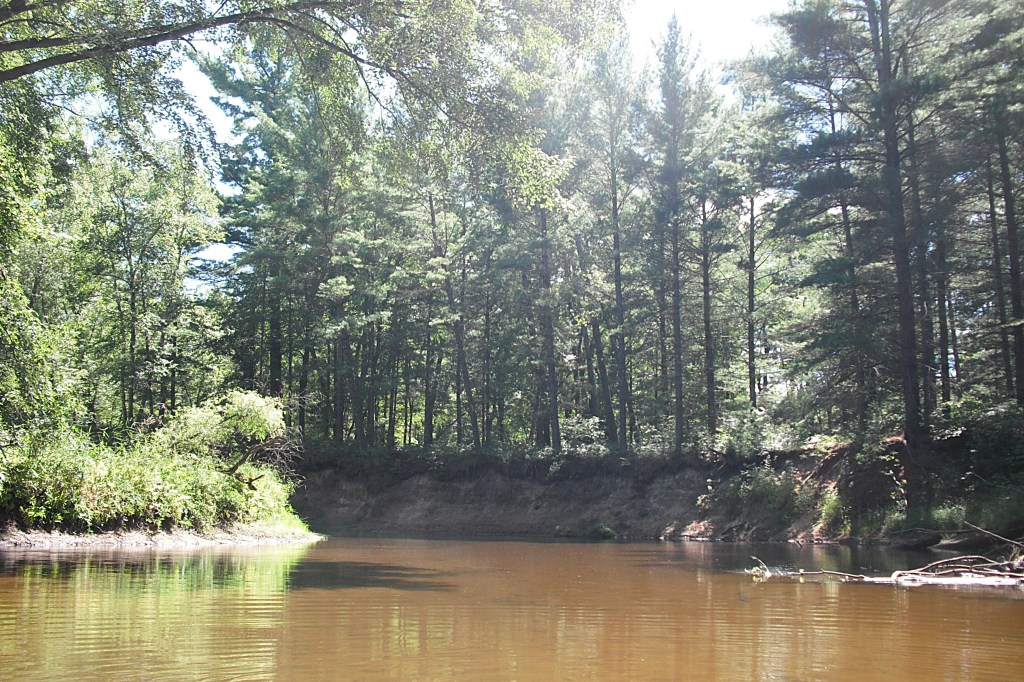
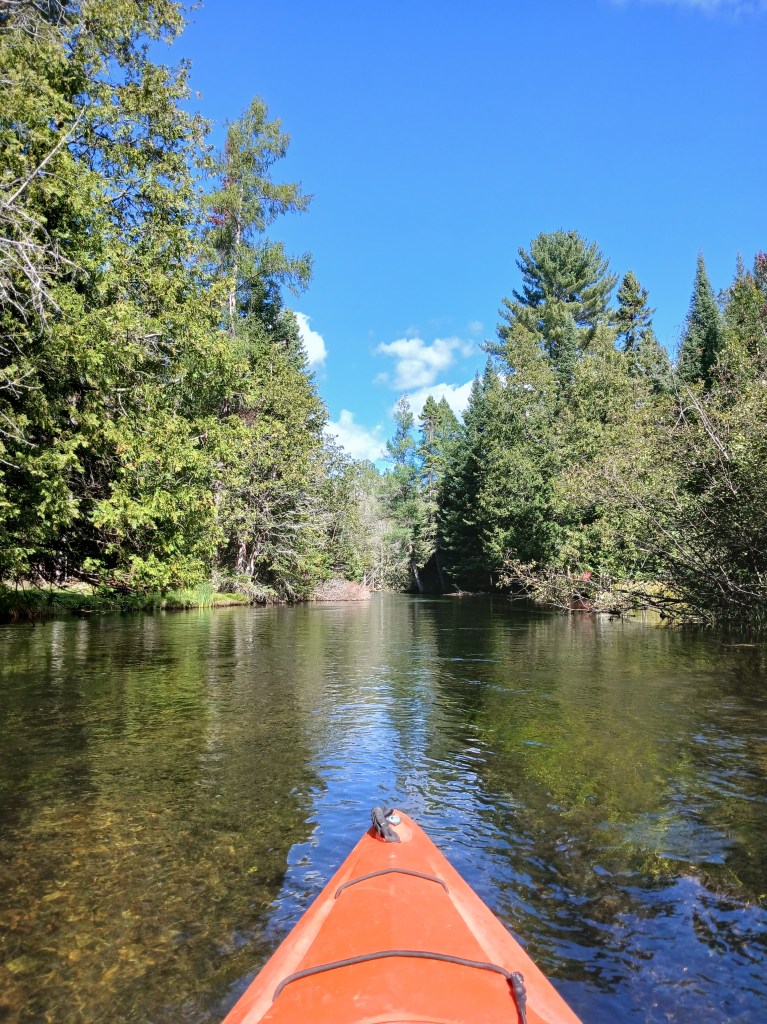
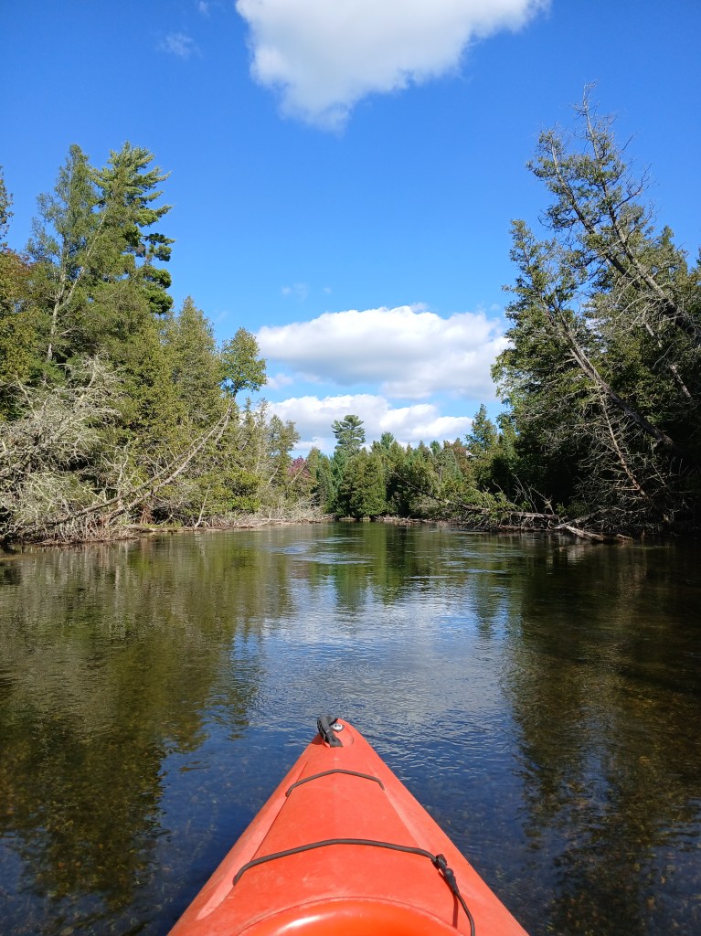
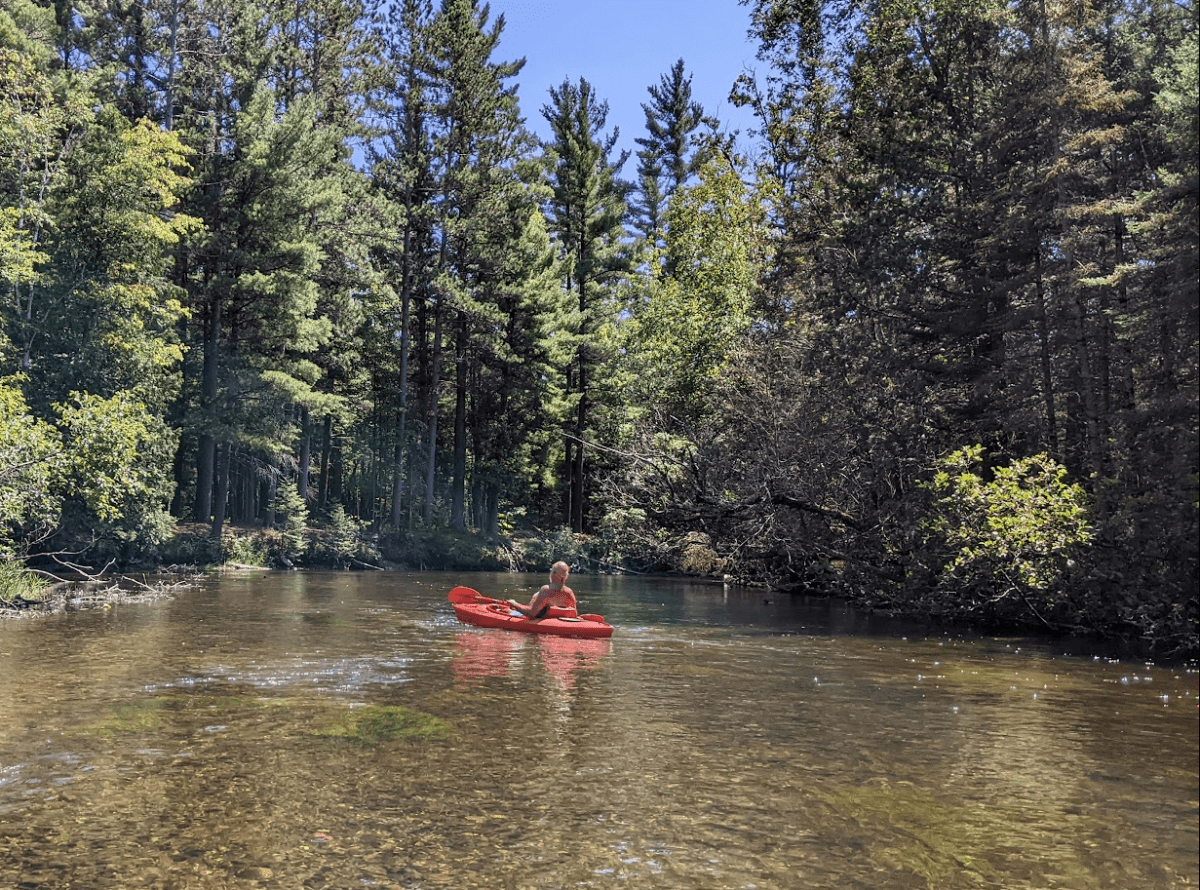
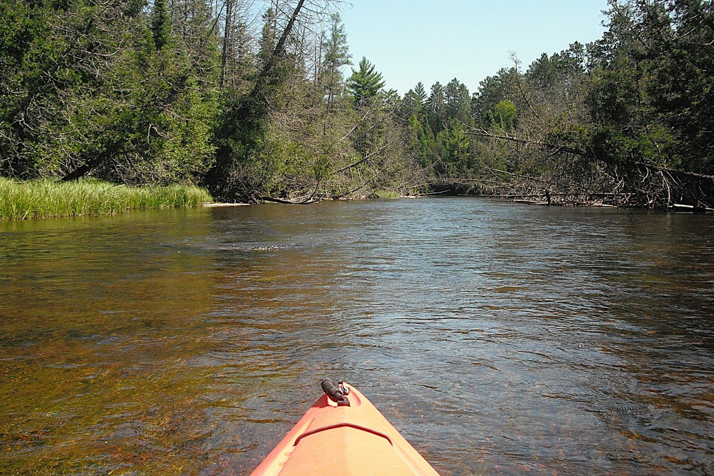
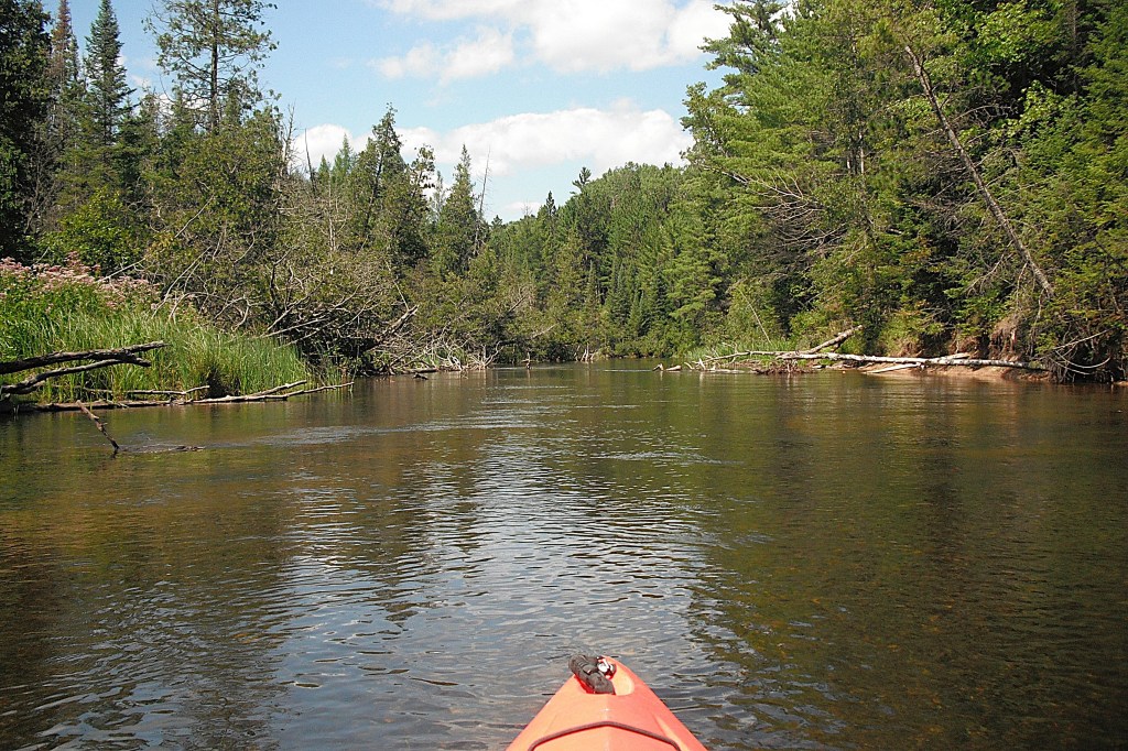
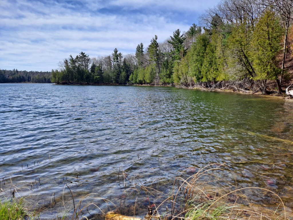
The Au Sable River is 138 miles long and the watershed covers 1932 square miles. The mainstream forms in Frederic Township of Crawford County, flows through Ogemaw County, and empties into Lake Huron at the communities of Oscoda and Au Sable in Iosco County. The Au Sable is Michigan’s most famous trout stream.
My friend Dan is always looking for an excuse to go up north kayaking. When I mentioned a trip to the Au Sable, he was immediately on board! As you can see, sometimes he likes to relax while paddling. The Au Sable will do that to you.
We decided on a eighteen mile trip from Grayling to the Wakeley Bridge. There are three canoe/kayak liveries in Grayling. We chose Carlisle Canoe Livery for car spotting. Our trip was advertised at five and one half hours of paddle time. Our leisurely pace and stops for breaks stretched our trip to seven hours. Our voyage took place in early September of 2024 and we had the river to ourselves. This section of the Au Sable is an easy paddle. Basic kayaking skills are all that is needed. Please be courteous to the fishermen.
We started our trip at Carlisle’s on a warm sunny weekday morning. The portion of the Au Sable that we kayaked was clear, wide, and shallow. The current varied between slow and moderate over a mostly gravel and rock bottom with some sand. Trout habitat structures have been placed in some sections of the river. The shoreline is forested and dotted with homes and cottages. The dwellings generally did not stand out, but blended in with the wooded riverbanks. Erosion control has been placed along the river’s edge where needed.
What you can expect as you travel downstream: I75 spans the river shortly after leaving Grayling. Burton’s Landing State Forest Campground is eight miles downstream from Grayling. Keystone Landing State Forest Campground and the Whirlpool Access are next. Continuing down river, Stephan Bridge Landing is thirteen miles from Grayling. Wakeley Bridge Landing marks the end of the trip, eighteen miles from Grayling. All of the landings feature vault toilets. The two campgrounds have potable water.
The Au Sable River isn’t particularly remote, but it has that middle-of-nowhere feel. The scenery rivals any Michigan river. This was my second trip on the Au Sable and I’ll keep coming back for more!
The Au Sable River is internationally known for its exceptional trout fishing. I think it’s the most scenic river in Michigan’s lower peninsula!
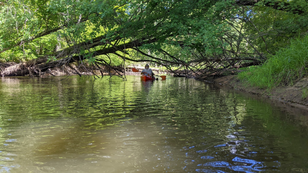
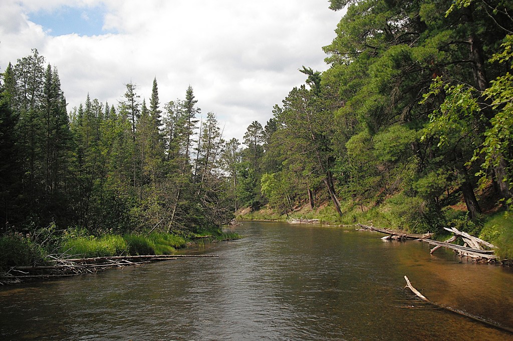
The riverbanks are lined with cedars and pines. Some of the pine trees are virgin old growth and they tower above the forest canopy.
Cold water springs are abundant along the shoreline. The current flows at a moderate to fast rate over a mostly gravel and rock bottom. The water depth is one to three feet with some deeper holes.
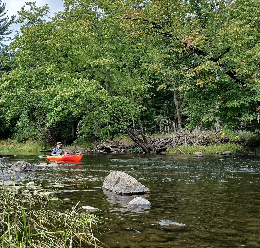
I teamed up with my friend Dan on this expedition and we hit the river on a warm sunny weekday in August of 2022. We contracted with Paddle Brave Camp and Canoe in Roscommon for car spotting. We also began our trip at their location. We saw less than a half dozen other paddlers while we were on the river.
This stretch of the South Branch Au Sable River is relatively easy to paddle, leaving kayakers plenty of time to enjoy the beautiful scenery.
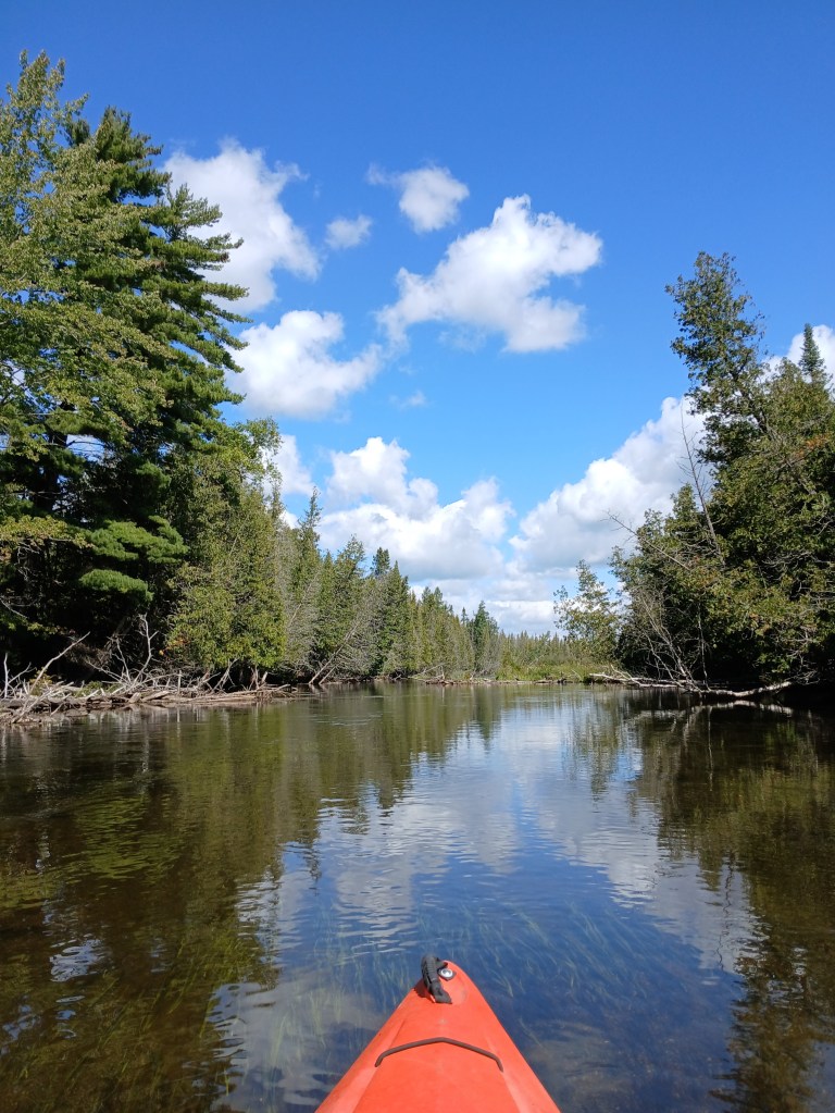
The many downed trees in the river are next to shore, leaving the middle of the waterway open.
Some maneuvering is necessary from time to time. Very shallow water and large rocks can be a concern if you’re not paying attention.
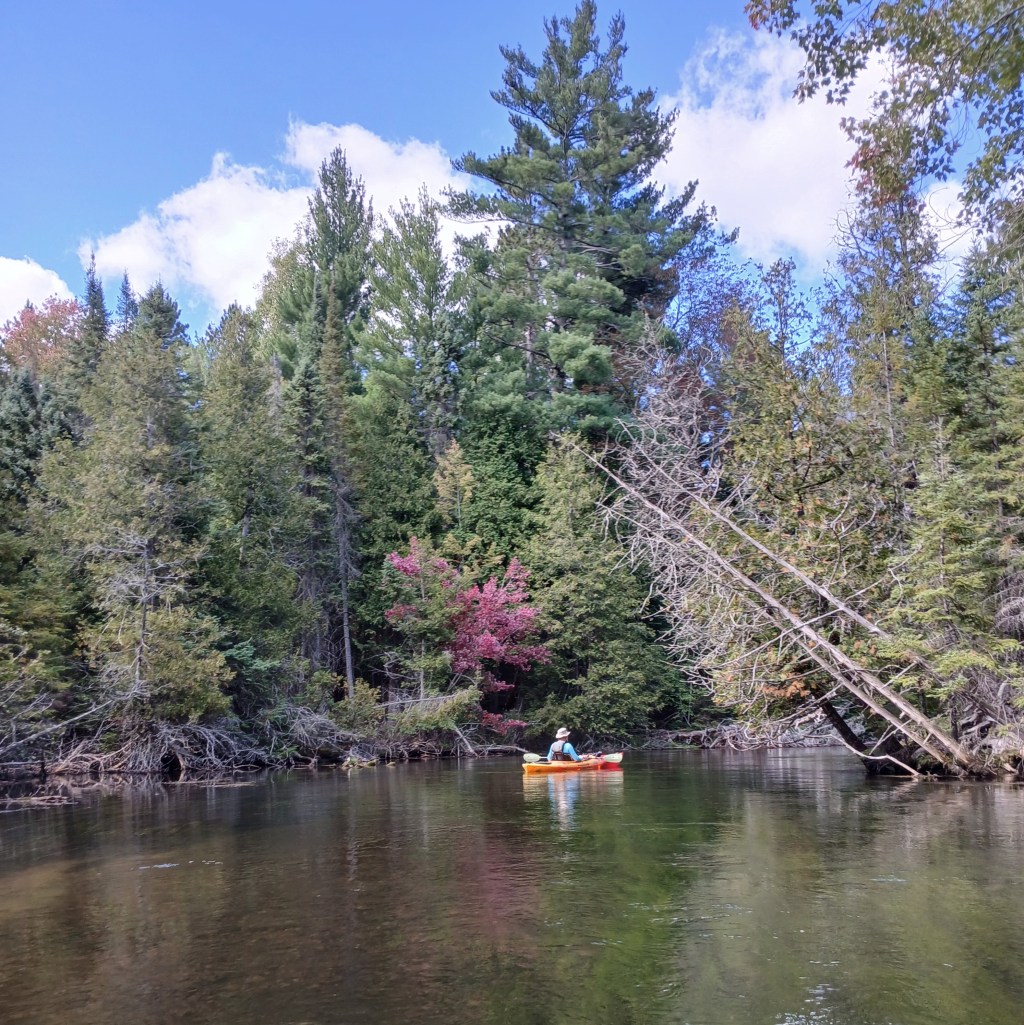
The first part of the trip, from Paddle Brave to the Chase Bridge, features wooded shorelines punctuated with homes and summer cabins. There is a boat landing at the Chase Bridge.
From the Chase Bridge to the M72 Smith Bridge, the river flows through the Mason Tract.
Auto magnate George Mason purchased that tract in the 1930’s and bequeathed it to the State of Michigan upon his death in 1954.
This stretch of the river is remote and secluded. It was our favorite part of the trip.
There was only a couple signs of civilization between the Chase Bridge and the Smith Bridge. The first is a dock with a footpath up a hill to the site of the fifty four room Durant Castle. It burned down shortly after its completion in 1931 and was never occupied. There’s nothing left to see. It’s not worth a look.
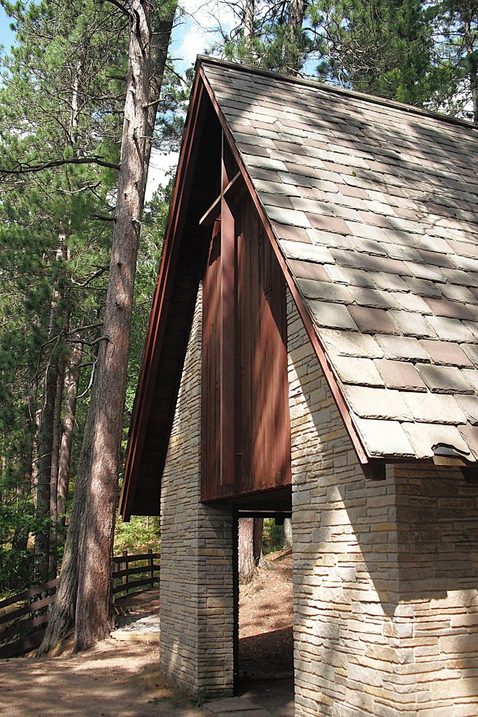
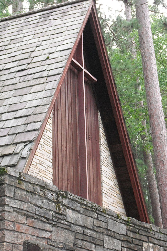
Farther downstream, another dock and footpath takes Au Sable travelers to a open-air chapel on the side of a hill overlooking the river. The chapel was built in the 1960’s as a memorial to George Mason by his family.
Our adventure continued. More beautiful scenery awaited us around every bend in the river.
Homes and cabins began to appear on the riverbanks as we got close to M72. Our trip ended at the Smith Bridge, where M72 spans the river. It’s a spacious landing with ample parking and a vault toilet.
Of all the rivers in the lower peninsula, the Au Sable should be first on your bucket list!
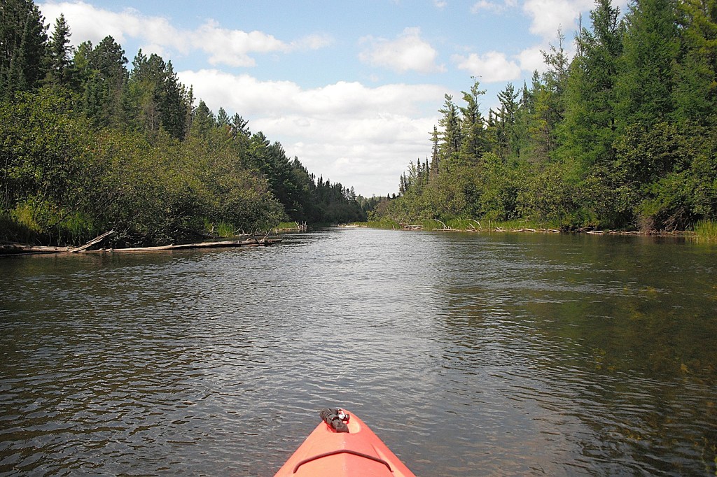
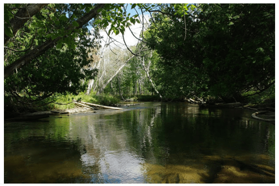
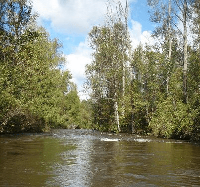
The Sturgeon River is the fastest flowing river in Michigan’s lower peninsula and also the most difficult for kayakers. It has the steepest gradient, dropping an average of fourteen feet per mile of river. That translates to a two hundred and ten foot drop during the length of my trip! This portion of the Sturgeon is noted for its sections of class I and II rapids, whitewater, standing waves, and a couple of three foot drops. There are many hairpin turns as well. Obstacles include the usual trees, logs, branches, and rocks. This stretch of the river varies in width from thirty to fifty feet, with a few spots that are narrower. I kayaked the river in early September and I never saw another boater.
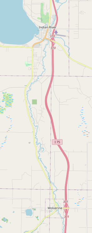
The Sturgeon River, between Wolverine and Indian River, is not suitable for beginners or inexperienced paddlers. I am still amazed that I conquered it without tipping over. My kayaking resume’ includes almost every river in southwest Michigan and those waterways were invaluable in preparing me for the Sturgeon. Experience and boat position are the keys to successfully paddling this river. As soon as you negotiate one obstacle, get in position for the next one or two obstacles. Always plan ahead. Never wait until the last minute. In rapids and whitewater, my experience helped me to instinctively react to the situations. I didn’t have to think about what to do. It came to me automatically. If you have to think about it, then it’s too late. This stretch of the Sturgeon River can be dangerous for beginners and inexperienced kayakers. The strong current shows no mercy. There’s always the possibility of injury if you don’t know what you’re doing. Be alert, observant, and ready at all times! Position!!!
The paddling portion of my excursion started in the village of Wolverine, but my trip began at a watercraft livery in the village of Indian River. The owner of the business gave me a briefing about the river. The information that she gave me was instrumental to my success. At one point, she instructed me on what to do WHEN I tipped over, not IF I tipped over. What a confidence builder!
The livery provided transportation for me and my kayak to the launch site in Wolverine. The driver gave me some tips that were very helpful. There were two other kayakers riding with us. They were taking a shorter trip, so we were dropping them off first. We drove across a bridge over the Sturgeon to get to their launch site. From the bridge, I got a good look at the river for the first time. All I saw in both directions were rapids. My confidence was eroding further with every passing minute. We arrived at the launch site in a park on the north side of the village of Wolverine. The driver wished me good luck and drove off. I was on my own with fifteen miles of river in front of me.
I was still a little nervous when I shoved off from the landing. Within the first half mile, I encountered my first rapids with standing waves. After successfully paddling that stretch, I felt ready for whatever the river would throw at me. A little success gave my spirits a big boost!
The river corridor is mostly forested with a few sections of open country. In some places, cedar trees lined the river banks, some leaning over the river at odd angles. Enjoying the strong aroma of the cedars while paddling a scenic river is what kayaking is all about! Sometimes, it’s hard to enjoy the scenery because paddling demands most of your attention.
There are very few homes on the banks of the Sturgeon until you get to the village of Indian River. There are a few roads that cross over this stretch of the river and they are, from south to north, Scott Road, Rondo Road, South and North White Road, and highway M68. There is a state forest campground named Haakwood on the west side of the river, on South Straits Highway, between Scott Road and Rondo Road.
I can’t possibly recount every mile of my voyage, but I can tell you a couple of stories that are representative of what you may encounter when kayaking the Sturgeon.
About halfway through my trip, I rounded a hairpin turn and was greeted by two fallen trees blocking the river. I immediately paddled backward and slowed to a crawl, out of the strong main current. The tangle of tree trunks, limbs, and roots looked impassable. The current had created a scour hole under the trees, so getting out of my kayak and wading it through was not an option. The shore was thick with vegetation, so a portage was out of the question. I picked a likely spot and slowly drifted into the tangle. I didn’t go very far before the current pushed and pinned me against the base of a tree. My kayak began to tip. If it filled with water while pinned against the tree, my trip would be over. I couldn’t use my paddle because of all the tree branches, so I stuck it in my cockpit. I inched myself forward by grabbing branches and pulling my kayak ahead by hand. I pulled myself over, under, and through the trees until I was finally able to paddle my way clear of the tangle. It was very slow going and it seemed to take forever to get through. I was happy to leave those trees behind me!
A while later, I was paddling a short, straight section of the river when I spotted a good sized log blocking the river from bank to bank, with water flowing over the middle of it. I decided to speed up and slide over it. When I got to the point of no return, I saw that there was only a little water flowing over the log. There was a drop-off of over a foot on the downstream side of it. I slid about half way over the log and came to a stop. I was sitting on top of it with the front half of my kayak out of the water by a foot. The water looked deep. Because of my age, my agility had left me, along with my youth. Getting out of my kayak while on top of the log was not an option. I decided to use inertia to “scoot” my kayak the rest of the way over the log. It’s just like sitting in a chair and “scooting” it up to the dinner table. It works for me all the time. I “scooted” a few inches at a time and my kayak finally started to slide over the log. As soon as my bow hit the water, a eddy current pulled it towards the log while the stern was still on top of the log. When the stern fell off the log, it was pulled up to the log too. I found myself up against the log, parallel to it. My kayak began to wobble side to side, back and forth, threatening to tip over. I grabbed the log with one hand and the wobbling stopped. How I didn’t tip over was beyond me! What next? The only way out that I could think of was to push off the log and hope for the best. I braced myself for the rush of cold water that happens when you tip over. I gave a good strong push-off from the log and I floated gently downstream, right side up! The outcome was much better than I expected!
These are just a couple of the many challenges that faced me on the Sturgeon.
My trip was nearing the end when I approached the village of Indian River. The current gradually slowed and the obstacles were fewer in number. I could relax and enjoy a beer, instead of grabbing a hurried slug here and there. Soon, I was paddling along the backyards of homes in a residential area of the village. I passed under the M68 bridge and entered Burt Lake State Park. Downstream from the bridge, there is a sturdy dock at the base of a steep hill on the left bank of the river. A set of stairs with a canoe/kayak slide next to it leads from the dock to the top of the hill. You will appreciate the slide after a long day on the water. The parking area at the top of the hill is just for loading and unloading. Longer term parking is nearby.
I was tired after I loaded up my kayak and gear , but it was a good tired. I had successfully kayaked the most difficult river in the lower peninsula and the feeling was rewarding, almost euphoric. You will know that feeling when you complete this voyage! Good Luck!
Wilderness State Park is aptly named. During my voyage, I didn’t see another person or boat. There wasn’t a single sign of human activity. It felt like I was out in the middle of nowhere. It was truly the boonies!
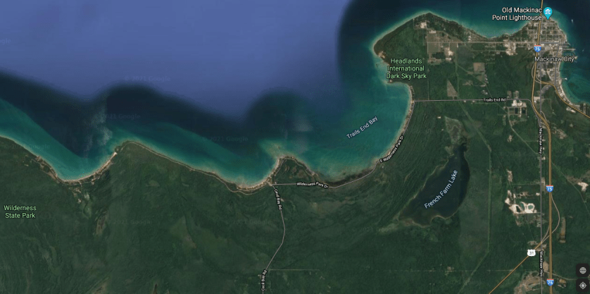
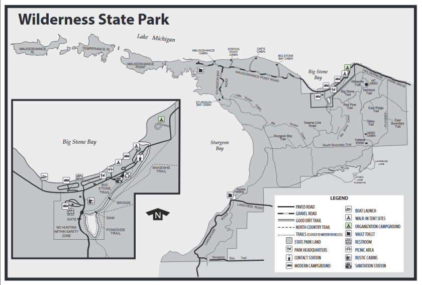
Wilderness State Park encompasses over 8000 acres and includes more than twenty six miles of Lake Michigan shoreline. The part of the park that is most interesting for kayakers is a peninsula called Waugoshance Point. Several islands extend west from the point. Temperance Island is one of the larger islands and is separated from Waugoshance Point by a channel called The Big Cut. Farther west, another large island is Crane Island, also called Waugoshance Island. There are also several other islands. The size and number of islands varies with the Lake Michigan water level. The shorelines of the point and the islands change with the fluctuating water levels. The west end of the Straits Of Mackinaw is north of the park. Sturgeon Bay is south of Waugoshance Point and the islands.
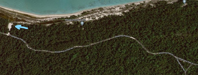
The easiest way to access Wilderness State Park is from Mackinaw City. Head west from Mackinaw City on either Central Avenue or Trails End Road. The two roads intersect Wilderness Park Drive, which will take you to the park. Wilderness Park Drive follows the shore of Lake Michigan, offering views of Trails End Bay, Cecil Bay, and Big Stone Bay. There is a park boat landing on Big Stone Bay. Once inside the park, continue west on Wilderness Park Road, also called Waugoshance Point Road.
If you are paddling the north side of the point, continue west on Waugoshance Point Road, past Sturgeon Bay Road. There is a parking area on the north side of the road. It’s a short carry to the lake.
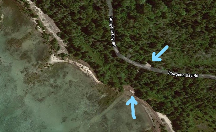
If you are kayaking the south side of the point, head south on Sturgeon Bay Road from Waugoshance Point Road. You will come to a closed gate and a small parking area. A short trail leads to Sturgeon Bay.
Your decision on which side of the point to kayak is dependent on wind speed and, primarily, wind direction. A north wind dictates paddling the south side and a south wind dictates paddling the north side. Obviously, if there is little to no wind, either side of the point is a good choice. I recommend viewing the lake conditions on both sides of the point before making your choice. Also, check a reliable marine weather forecast. A forecasted change in wind direction is a game changer. If you are paddling with the wind and waves, make sure that you are capable of paddling against the wind and waves on your way back. Lake Michigan is nothing to fool around with. Several weeks before I visited these waters, a kayaker paddled out to the point and couldn’t make it back. He had to be rescued. Don’t be that guy!
My trip took place in September of 2019 during high water levels on Lake Michigan. On the day of my voyage, the wind was from the east. After viewing the conditions on each side of the point and rechecking the marine forecast, I decided to kayak Sturgeon Bay. The waters of the Straits of Mackinaw were too rough.
West of the Sturgeon Bay boat landing, there are three unnamed points that I will call East, Middle, and West Points. Goose Bay is between East Point and Middle Point. A unnamed bay that I will call West Bay is between Middle Point and West Point. West of West Point, the shoreline curves northwest towards The Big Cut. The lake bottom is covered with rocks and boulders, some of which lurk just below the surface of the water. Much of the coastline is flooded and is lined with brush and small trees sticking out of the water. In some places, trees stick out of the water far from shore. Dry ground is hard to come by.
I hoped to paddle to the tip of Waugoshance Point and cross The Big Cut to Temperance Island. Since I didn’t know how long it would take to get there, I decided to take a more direct route and do my exploring on the way back. Heading West from the landing, I paddled across the mouth of Goose Bay, from East Point to Middle Point. The east wind was picking up, so I paddled West Bay closer to shore. The waters were somewhat calmer in the bay. When I reached West Point, the wind was considerably stronger. When I left the protected waters of West Bay and rounded West Point, the conditions were much worse than I expected. Large waves and high winds were pushing me westward at a pretty good clip. After traveling a couple hundred feet, I realized that I was going to have a hard time getting back. I reluctantly turned around and faced the wind and the waves. I wasn’t making much forward progress. I picked a reference point on shore and checked its location, relative to my position, from time to time. I was barely moving. I thought about the kayaker that had to be rescued because he couldn’t make it back. I picked up my pace, paddled as hard as I could, and slowly made my way back to West Point. Paddling hard is putting it mildly. Waves broke over my bow many times, but only a couple of them washed into my cockpit. I finally rounded West Point into the less windy waters of West Bay.
Luckily, West Point is one of the few places along the Sturgeon Bay shore of Waugoshance Point that has dry ground. I found a small, narrow sand beach on the thickly wooded point that wasn’t blocked by flooded bushes and trees. I beached my kayak and took a well deserved break. Beer time! My arms were tired from the intense paddling, but it didn’t take long for me to feel rejuvenated. I was glad that I turned around when I did!
It was time to explore! The flooded shorelines of West Bay and Goose Bay have many channels, coves, and ponds to paddle. In some places, you have to travel through flooded brush and small trees to get to some of the waterways. Sometimes, it takes some searching to find a water trail that will take you where you want to go. The water is mostly shallow. These wetlands are a unique feature to explore. I’ve never seen anyplace like it that you can access with a kayak. My explorations of the two bays was in less windy conditions than the offshore waters, so that was a bonus.
On West Bay, I followed channels and ponds as far north as I could paddle. The land surrounding the north end of the waterway was mostly sand covered with dune grass, with a few scrubby trees and bushes scattered about. I think it’s called a interdunal wetland. I could hear the unmistakable sound of pounding surf. I beached my kayak and walked north a hundred feet over a low sand dune. Lake Michigan was at my feet! I was on the north side of Waugoshance Point! A beautiful sand beach extended in both directions as far as I could see. Under a cloudless sky, white-capped waves glistened in the sun. Across the Straits of Mackinaw, the outline of the upper peninsula was visible on the horizon. There wasn’t a person in sight. When you kayak, you can find scenic areas that most people will never see.
I made my way back to West Bay and continued east to Goose Bay, exploring as I went. By the time I finished touring the backwaters of Goose Bay, it was getting late in the afternoon. I paddled back to the boat landing, ending a perfect day on the water.
When you visit Wilderness State Park, the waters of Waugoshance Point may look entirely different than the way it looked when I was there, due to the varying water levels of Lake Michigan. The elevation of most of Waugoshance Point is only slightly higher than the water level of the Big Lake. Some of the islands that are visible during low water will disappear during high water. Shorelines will change from year to year. If the water levels drop, some of the areas that I paddled might be dry land. In the end, it doesn’t really matter if the water levels of Lake Michigan are high or low. Waugoshance Point will always be a great place to kayak!
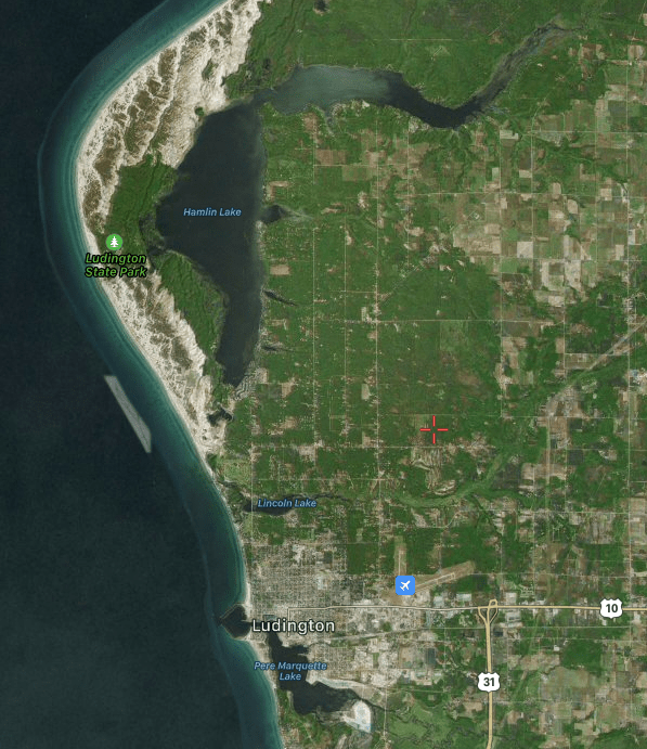
For those of you who are not familiar with the northern lower peninsula of Michigan, Ludington is a port on the shores of Lake Michigan, between Big Sable Point and Little Sable Point, north of the city of Muskegon and south of the city of Manistee. Two major highways intersect at Ludington: US10 and US31. Ludington is a tourist town and has many options for camping, lodging, food, and shopping. It is the home port for the S.S. Badger of the Lake Michigan Car Ferry line. The Pere Marquette River, the Sable River, and the Lincoln River flow into Lake Michigan in the Ludington area.
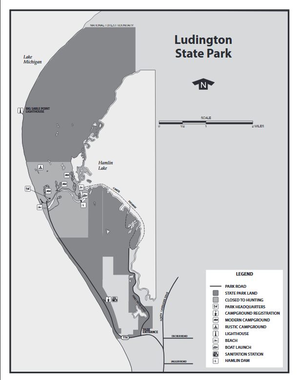
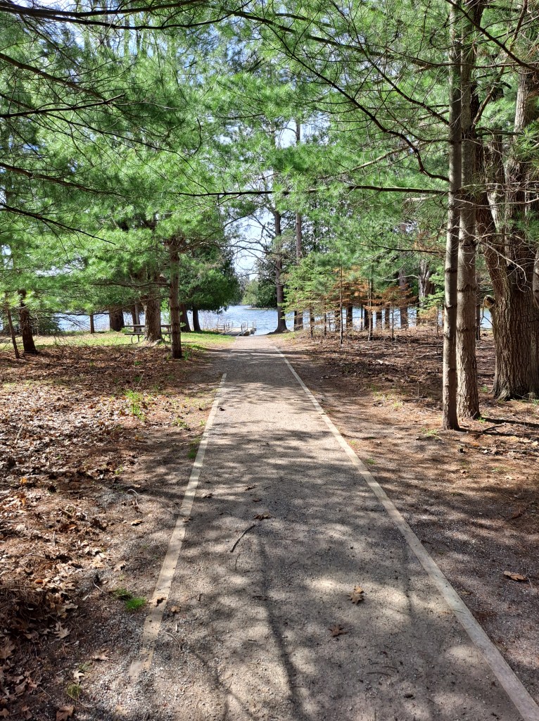
The highlight of the area for kayakers is a very short drive north of Ludington: Hamlin Lake and Ludington State Park. Hamlin Lake consists of two distinct bodies of water that are connected at the “Narrows”: Upper Hamlin and Lower Hamlin. Hamlin Lake is an impoundment of the Sable River, which flows into the east end of Upper Hamlin. The dam is located roughly in the middle of the west shore of Lower Hamlin, in the state park. Below the dam, the Sable River continues through the state park and into Lake Michigan. At the northwest corner of Lower Hamlin, sand dunes rise up from the water’s edge and stretch for a mile and a half along the shore. These dunes can be seen from all over the lake. Hamlin Lake and the connecting waters will keep kayakers busy for several days. Because Hamlin Lake is an impoundment of a river, kayakers should beware of submerged stumps and trees that lie just below the surface of the water. Because of the large size of Hamlin Lake, winds can whip up large waves up to three feet in height. When these conditions exist or are forecast, exercise good judgement when attempting a trip that includes a open water passage. The waters in the Ludington area can be quite busy in the peak summer months. My Ludington kayaking trips have all been in early September and I rarely see other kayakers. Specific information on the waters of the Ludington area that I have kayaked is next. I encourage you to paddle the scenic waterways of Mason County. You will be glad that you did!
WEST SIDE LOWER HAMLIN LAKE
Use the Ludington State Park boat launch site for all kayaking trips on the west side of Lower Hamlin Lake. This includes Lost Lake and surrounding waters, and the Ludington Canoe Pathway. Take highway M116 north from Ludington to the state park. Follow the park signs to the Hamlin Lake boat access site. It is right next to the Hamlin beach and beach house. You can rent watercraft at the beach house. Let’s go kayaking!
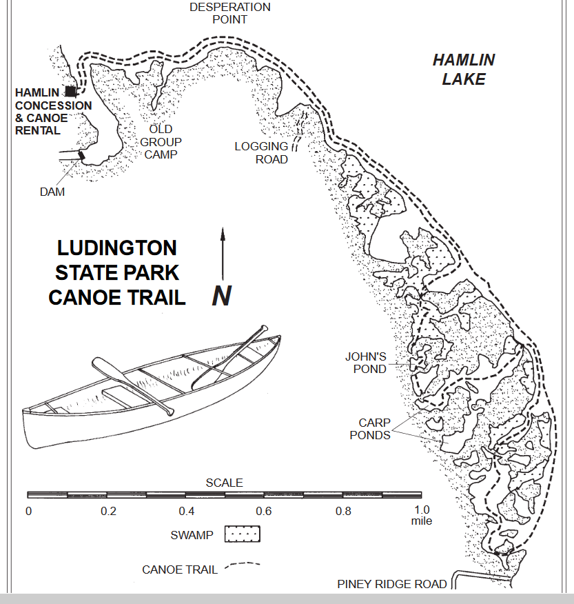
LUDINGTON CANOE TRAIL
Following this beautiful, scenic water trail will take you through a series of bays, coves, and ponds that are west of the main basin of Lower Hamlin Lake. You will enjoy heavily wooded shorelines, wetlands, and abundant wildlife on this trip. This voyage is for paddlers of all skill levels.
After launching your kayak at the state park boat landing, head east across the wide channel and follow the shoreline north. Continue following the shoreline as it curves east. You will see the open waters of the main basin up ahead. When you reach the main basin, follow the shoreline south to the first of two inland portions of the water trail. Between the two portions, the water trail briefly returns to the main basin of the lake. The trail is marked by sign posts. I recommend that you take your time and explore the different coves, bayous, and ponds as you navigate the two inland portions of the water trail.
The two inland portions have five portages. Four of the five portages are marked by signs and are not hard to find. These portages are easy and short. The longest is only about thirty feet. There is a short dock at each end of four of the portages. There is a portage at the end of the first inland portion, where the water trail returns to the main basin of the lake. The last time I kayaked the water trail, this portage was hard to find, hidden by thick cattails.
After returning to the main basin from the first inland portion, follow the shoreline south to the second inland portion of the water trail, which is marked by signposts. There are more coves and ponds to explore.
A bayou at the south end of the second inland portion of the water pathway will take you back to the main basin of the lake. There are a few homes and cottages on this bayou as you get close to the lake. Once you emerge from the bayou and you are on the main basin, follow the shoreline north to the boat landing.
What you can expect as you paddle the two inland portions of the water trail: The water is shallow for the most part. In a few places, you may have to search for water that is deep enough to float your boat. The water alongside some of the portage docks is very shallow. You may have a hard time getting to or from these docks. Occasionally, aquatic vegetation can be thick and difficult to paddle through. Submerged stumps and trees are waiting for the unsuspecting paddler.
If the wind is from the north, northeast, east, or southeast, the portion of the water trail that follows the shoreline of the main basin of Hamlin Lake might be difficult to paddle due to large waves.
This guide has additional information in detail that will help you enjoy the water trail. I have found the guide to have a few inaccuracies, but they are very few in number. For the most part, the guide is correct:
Have fun and be safe!
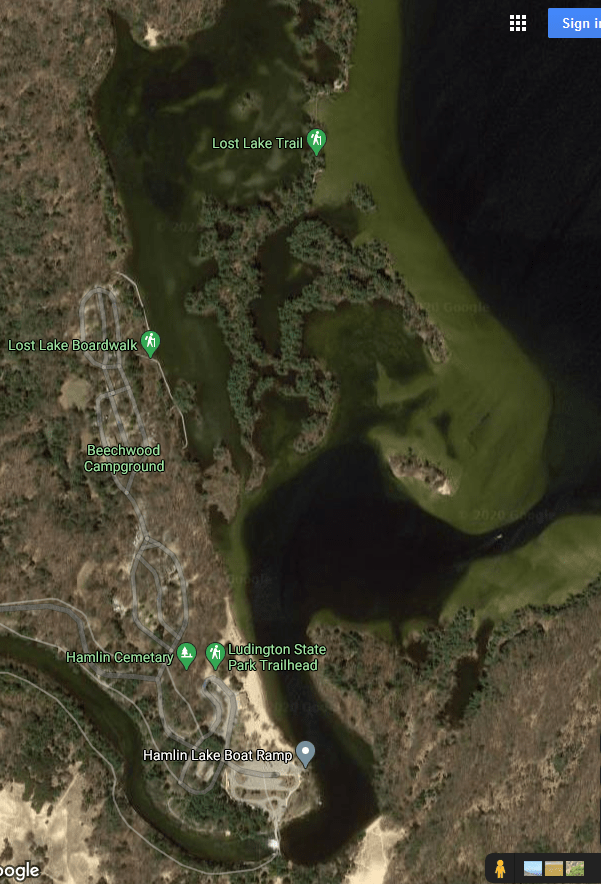
LOST LAKE AND SURROUNDING WATERS
Kayaking some portions of this area will require paddling the main basin of Lower Hamlin Lake. You may be exposed to wind and large waves. If these conditions exceed your capability, change your itinerary to protected waters, out of the wind.
This part of Lower Hamlin is known for its exceptional scenic beauty. There are islands, coves, and bayous to explore. It may take you more than one trip to kayak this portion of the lake at a leisurely pace.
South of the boat ramp, the wide channel curves to the southwest and the Hamlin Dam spans the channel. At the curve, there is a sand dune at the water’s edge that makes for a dandy swimming spot.
North of the boat landing, the wide channel empties into a large bay with an island on the east end. The main basin of Lower Hamlin is on the east side of this island. On the south side of the bay, there is a small cove and a long narrow bayou to explore.
On the northwest end of the bay, there is a wooden foot bridge over the south channel to Lost Lake. Lining the west shore of Lost Lake is a boardwalk and one of three park campgrounds. There is a tall sand hill on the north end of the lake. A second wooden foot bridge spans the north channel to Lost Lake. On the east side of Lost Lake, the land between the two foot bridges is a large, spider-like island. I recommend paddling all the way around this island. Explore every nook and cranny of the island’s shore and you will be rewarded with scenic views of its bays, hidden coves, passages, and smaller islands.
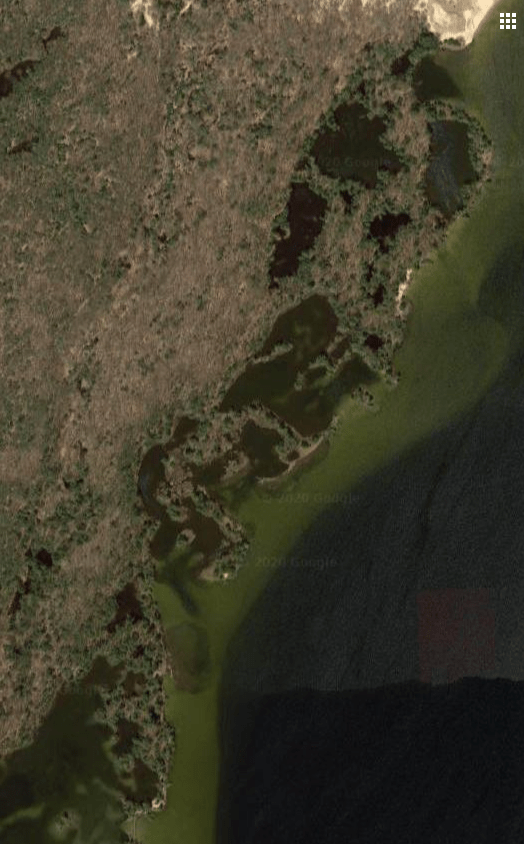
The Lost Lake north channel is at the bottom left of the satellite photo and the beginning of the sand dunes is at the top right.
Exiting Lost Lake at the north channel will take you to the Lower Hamlin Lake main basin. Follow the shoreline north to get to the sand dunes. On the way, there are several coves to explore. Parts or all of some of these coves are choked with reeds and other aquatic vegetation, making them difficult to paddle. The northern-most cove is right next to the dunes and is easy to paddle. There is a hiking shelter on the shore at the west end of the cove. North of the cove, you can paddle the sand dune shoreline to your heart’s content. The dune coastline is a great place to stop and take a break or a extended stay before heading back to the boat landing.
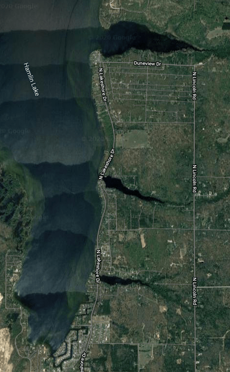
EAST SHORE LOWER HAMLIN LAKE
This trip is for kayakers who enjoy paddling lakes with developed coastlines. The shores of this portion of Lower Hamlin are lined with homes, cottages, and resorts. The coastline is relatively straight and is punctuated by three bayous: North, Middle, and South. Each bayou is fed by a small stream on its east end. The South and Middle Bayous are fully developed, while the North Bayou is sparsely developed.
This is usually the windy side of the lake, so large waves are a frequent occurrence. If you are unsure of your ability to handle rough water, wait for calmer conditions.
Head north on highway M116 from Ludington. When the highway curves to the west, continue straight, north, on Lakeshore Drive. There are two public boat landings on this side of Lower Hamlin. One landing is south of the mouth of the North Bayou. Turn west at the intersection of Lakeshore Drive and Duneview Avenue. The landing is straight ahead. I chose to use a boat launch that is on the South Bayou simply because I thought it was more scenic. This landing is on the east side of Lakeshore Drive, south of the bridge over the South Bayou Channel.
Kayakers should be especially observant when paddling the North Bayou. It is littered with submerged and emergent trees. The Middle Bayou, South Bayou, and the Hamlin shoreline that is in between the three bayous are mostly free of underwater obstructions.
I paddled the creek that flows into the east end of the Middle Bayou until I was stopped by shallow water. The small stream is a tranquil, shaded, quiet place. I didn’t visit the creeks that feed the other two bayous, but I think that they would be equally pleasant.
I recommend exploring the shorelines of the three bayous and the adjacent main basin coast. I found it picturesque to paddle.
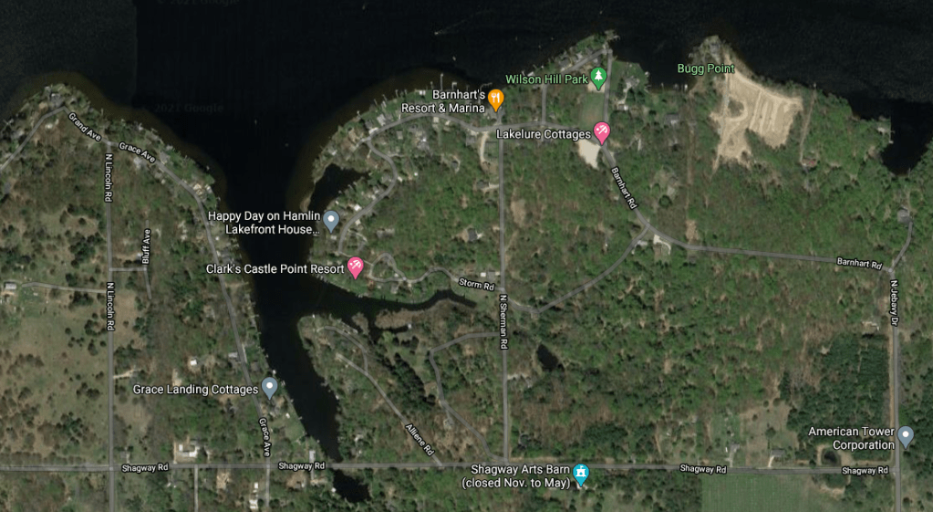
SOUTH SHORE UPPER HAMLIN LAKE
Another developed shoreline that you may find interesting is the west end of the south shore of Upper Hamlin Lake. Take Jebavy Drive north from US10 in Ludington. The road curves northwest and is then called Barnhart Road. Turn north on Beech Lane. Wilson Hill Park and the boat ramp are straight ahead.
Explore the coastline in both directions from the boat launch. Paddling the shoreline west will take you to one of the features of Upper Hamlin, Indian Pete Bayou. If you liked the east shore of Lower Hamlin, then you will enjoy this portion of Upper Hamlin!
EAST END UPPER HAMLIN LAKE
The east half of the north shore of Upper Hamlin Lake is part of the Huron-Manistee National Forest. The far east end of the upper lake and the Sable River are within the national forest. The east half of the south shore of Upper Hamlin has very little development. The area where the Sable River flows into Upper Hamlin can best be described as a river delta. As a kayaker, these features make the area appealing to me. I hope it appeals to you, too!
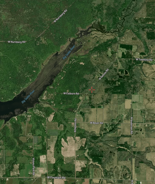
There is a lake access site on the north side of the lake, close to the river delta. Take Nurnberg Road west from Quarterline Road. Turning south on a United States Forest Service road will take you to the boat ramp. I chose to access the lake farther west, on the south shore, at Victory Park. Take Victory Park Road north from Fountain Road and the park is at the end of the road. I picked this boat landing simply because I wanted a longer trip.
The lake in front of the Victory Park landing has occasional areas of sparse reeds. The reed beds gradually grow thicker as you travel east until they cover the whole lake. In places, the reeds are so thick that they are difficult to paddle through. Don’t despair! There is a channel that runs through the reed bed, all the way to the delta! The west end of the channel is about twenty feet wide and gradually narrows to about five feet at its east end. There are some channels that branch off the main channel, but I didn’t explore them.
This closer view shows the channel through the reeds and the river delta in more detail.
For many kayakers, paddling through a reed-lined channel for a mile and a half is monotonous and boring. This was my first trip on this part of the lake and I didn’t know what was ahead. A satellite photo doesn’t come close to telling you what to expect. So, for me, this voyage was an adventure. I didn’t find it boring. Besides, how could I get bored with a cooler full of beer in my kayak?
At the east end of the reed-lined channel, the lake transitions to the Sable River Delta and the Sable River. The north and south shores of the lake gradually come together until they almost meet. There is a good-sized wooded island at the beginning of the delta. On the north side of the island, a channel swings by a point on the north shore. This is a great spot to stop and take a break. At the tip of the point, there is an open area at the base of a small hill. The top of the hill offers a nice view and a foot trail leads inland to the end of a USFS trail.
The delta continues upstream from the point and several channels wind their way through cattails, reeds, and grass. Eventually, the channels converge and the river emerges from the delta. I continued paddling up the river. After a while, the current grew stronger and I was making slow headway. It was time for a change in direction. I reluctantly turned around and headed downstream. I took one last break at the point and paddled down the lake to the landing.
It was a exceptional kayaking trip and I was glad that I went. I wouldn’t change a thing. I hope that you get a chance to kayak the east end of Upper Hamlin Lake. It’s a great place to paddle!
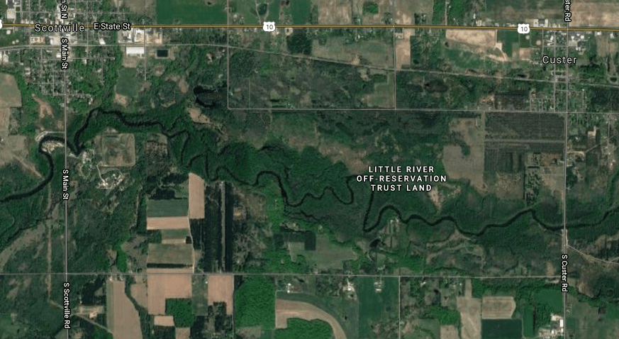
PERE MARQUETTE RIVER, CUSTER TO SCOTTVILLE
The lower Pere Marquette River is quite a bit different than the river’s upper reaches. This portion of the river is wider and deeper with slow to moderate current. It feels secluded and remote. The bottom of the river is mostly sand. The river banks are wooded, mostly hardwoods. Some of the land bordering this stretch of the river is Indian tribal land of the Little River Band of the Ottawa nation. This part of the river, from Custer to Scottville, is easy to paddle and is suitable for all kayakers, regardless of skill level.
My wife, Colleen, joined me on this summertime trip. She isn’t too keen on long, extensive voyages, so this shorter adventure was perfect. There were some kayakers, canoeists, and tubers running the river, but we didn’t see them very often. For the most part, we were by ourselves.
I used my own kayak and we rented one for Colleen at an outfitter in Scottville. The outfitter provided transportation for us and both kayaks.
The villages of Scottville and Custer are a short drive east of Ludington on highway US10. We began our trip at the Custer Road bridge, south of the village of Custer. There is river access on the south side of the river, on both sides of the bridge. We ended our trip at a park on Scottville Road, south of the village of Scottville. The entrance to the park is on the west side of the road, on the north side of the river.
We thoroughly enjoyed the scenic beauty of this stretch of the Pere Marquette River. The voyage was perfect for the two of us. We highly recommend this trip and if you go, we know that you won’t be disappointed!
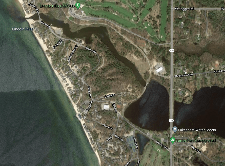
LINCOLN LAKE AND LOWER LINCOLN RIVER
Lincoln Lake and the lower Lincoln River are located north of Ludington on highway M116. You can’t miss it. A bridge carries M116 over Lincoln Lake, dividing it into two parts. Most of the lake is east of the bridge. A much smaller part of Lincoln Lake is west of the bridge. For convenience, I will refer to the two portions of the lake as East Lincoln and West Lincoln. The upper Lincoln River flows into East Lincoln at its east end. The lower Lincoln River flows out of West Lincoln at its northwest corner and continues on to Lake Michigan. The lake access site is on the south shore of East Lincoln, on the east side of M116, right next to the road and Cartier Park.
To begin the trip, head west under the M116 bridge into West Lincoln Lake. Straight ahead, west, is the scenic Mount Epworth. The Mount Epworth area is home to the Epworth Assembly, founded in 1894, and Epworth Heights, a resort community.
A bridge at the northwest corner of West Lincoln marks the outlet of the lake and the beginning of the lower river. This newer bridge is the site of a long gone railroad bridge for the Ludington And Northern Railroad. This rail line carried tourists between Ludington and Hamlin Lake until it went out of business in 1919. The rail line was then used by a sand mining company until 1982. The village of Lincoln, settled in 1851, was located roughly north of the bridge. It was once the county seat of Mason County and had a three story boardinghouse, homes, grist mills, sawmills, a courthouse, stores, a dock for ships, and a post office. The mills closed in 1884. The people deserted the village and it became a ghost town. Today, there is no visible sign of the village of Lincoln.
That’s enough history. Let’s get back to kayaking! The bridge at the outlet of West Lincoln Lake has low clearance and some parts of the underside of the bridge have jagged edges that are just waiting to scrape your head.
After emerging from under the bridge, the river passes by the north side of Mount Epworth on its way to Lake Michigan. The current in the lower Lincoln River is slow, almost nonexistent. It is about seven tenths of a mile, by river, from West Lincoln Lake to Lake Michigan.
There is a bridge with plenty of clearance just upstream from Lake Michigan. After the bridge, the river narrows to a walled channel that leads out to the Big Lake.
On the day that I made this voyage, there was a strong wind straight out of the west. A cloudless sky allowed the sun’s rays to reflect off the rough seas and whitecaps on Lake Michigan. The large waves glistened in the sun and were breaking at the end of the channel. Five foot swells rolled up the river, where they gradually dissipated. It was a sight that will last in my memory forever. I paddled into the channel and had a blast riding the swells up and down. The sensation was like riding a small rollercoaster. I didn’t venture out into Lake Michigan. The large breakers at the mouth of the channel and on the Big Lake made conditions unsafe.
After I finished playing on the swells in the channel, I paddled back upstream and across West Lincoln to East Lincoln. I still had energy left, so I toured the south shore of East Lincoln for a little while before heading back to the landing. East Lincoln and the upper Lincoln River seem ripe for further exploration.
I found Lincoln Lake and the lower Lincoln River to be scenic and fun to paddle. If you try it, you’ll leave with a smile on your face!
The Ludington area in western Mason County has a lot to offer kayakers and I hope you follow my advice and visit it soon!
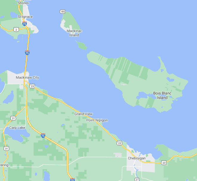
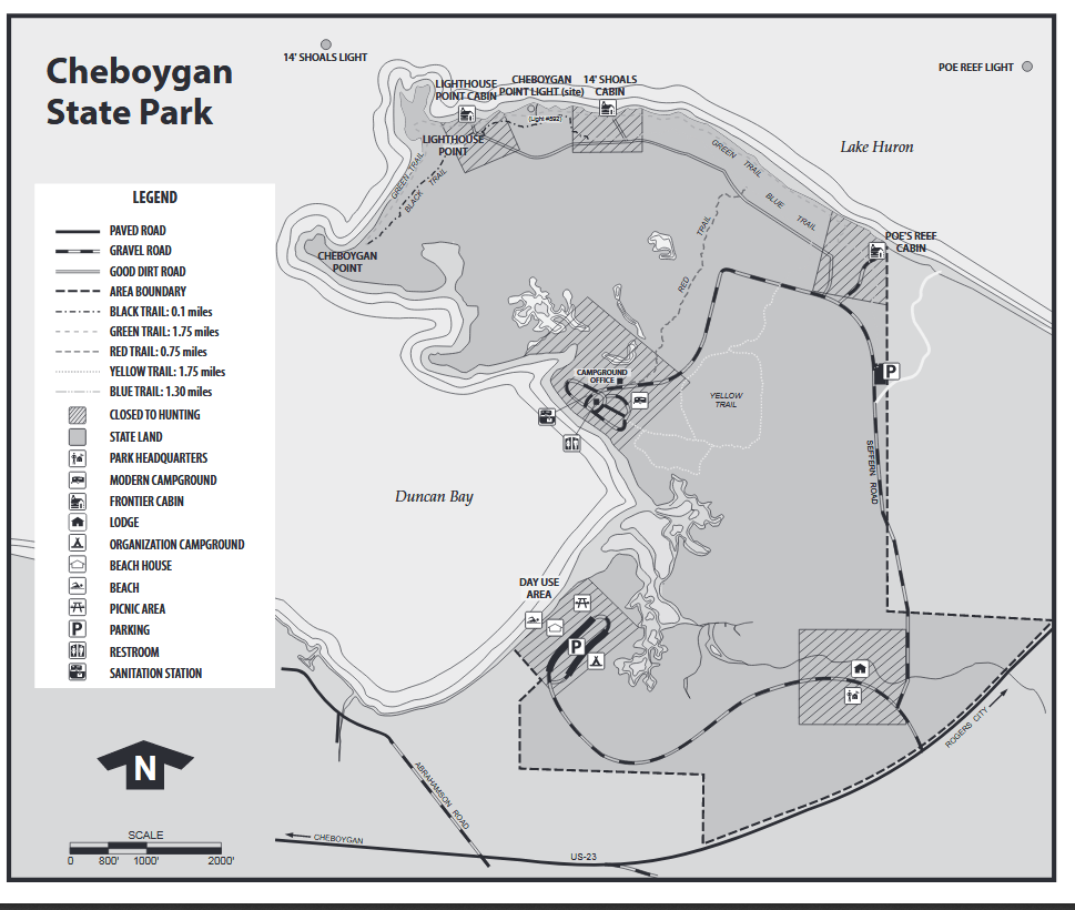
The city of Cheboygan is a port on the shore of northern Lake Huron, fourteen miles southeast of Mackinaw City and the Mackinaw Bridge. The city is serviced by highway US23. The thirty four square mile Bois Blanc Island is north of Cheboygan, separated from the mainland by the South Channel of the Straits of Mackinaw. East of Cheboygan, there is a portion of Lake Huron called Duncan Bay, where this voyage takes place. Duncan Bay is accessed from Cheboygan State Park.
The entrance to Cheboygan State Park is on the north side of US23, two and one half miles east of the Cheboygan city limits. Follow the park signs to the campground. A short trail between two campsites leads to the Duncan Bay access.
Duncan Bay is protected from winds coming from every direction but northwest. Unfortunately, on the day of my adventure, the wind was whipping from the northwest. The marine forecast had predicted it. I decided to go to the state park boat landing for a look-see. Upon observation, the conditions on Duncan Bay looked safe enough to paddle, despite the big waves. I would be paddling northwest, toward rougher water. I didn’t want to leave without giving it a try. Besides, quitting is for sissies.
The near-shore area of the crescent shaped east side of Duncan Bay is lined with reeds. My first objective was a unnamed point, a half mile northwest from the boat landing. I used the reeds to my advantage as I pulled away from shore. I stayed on the lee side of the thickest stands of reeds that I could find, while still maintaining my northwest course. The thick reeds dampened the waves, enough to make a difference. The reeds thinned out as I approached the point. I was exposed to the wind and waves for a little while, then the point offered me some protection from the adverse conditions.
I beached my kayak on the gravel point and got out to assess the situation. To the north, the wind was stronger and the white-capped waves were larger than they were in the area that I had just paddled. My next objective, Cheboygan Point, was a half mile away to the northwest, separated from my present position by a shallow bay. My initial reaction was to turn around and go back. After studying the waters and the coastline for a while, I decided that the conditions were not as bad as I first thought.
My strategy was to head straight north across the wind-swept waters of the bay and follow the shoreline west to Cheboygan Point. I would have to paddle broadside to the waves in the bay. I have experienced kayaking under similar conditions. I was able to establish a paddling rhythm that matched the rhythm of the waves. I safely crossed the bay without incident. I paddled west, as tight to shore as I could get without running aground. I was still feeling the wind and the waves, but it wasn’t as bad as the offshore waters.
Upon reaching Cheboygan Point, I beached my kayak and got out for a stretch and a beer break. The view from the point was nothing short of amazing! I felt the full force of that northwest wind and it was blowing furiously. The large, white-capped waves roared down the South Channel towards me. I could see all of Duncan Bay to the south and the city of Cheboygan to the southwest. To the northwest, Mackinaw Bridge appeared on the horizon. The large expanse of Bois Blanc Island filled my view to the north. Also to the north, on the mainland, I could see Lighthouse Point. Beyond Lighthouse Point, Fourteen Foot Shoal Lighthouse was perched on a offshore reef. I was mesmerized by the view.
Lighthouse Point, another half mile to the north, was my next objective. The lake conditions between Cheboygan Point and Lighthouse Point were much worse than the conditions on the previous part of my voyage. After considerable thought, I decided that the rough seas and the high winds were too much for me and my kayak. The lake finally won. It was time to head back to the landing.
Instead of retracing my previous course, I decided to cut straight across Duncan Bay, from Cheboygan Point directly to the boat landing. The wind and waves would be at my back for this leg of the voyage and my previous kayaking experience under similar conditions made it a good choice. You may think that paddling downwind with large waves is dangerous. It is actually quite safe and fun! When a big wave approaches you from behind, it looks like it’s going to wash over your boat. Just when you think all seems lost, the wave will pick up the stern of your boat and propel you forward, briefly surfing until the wave passes you. Your kayak will settle into the trough between the waves and you wait for the next wave to propel you forward. There is very little waiting because the waves are very close together. I used this technique on the one mile trip back to the landing and it was exhilarating!
If you are going to kayak the waters of Duncan Bay and Lake Huron at Cheboygan State Park, I hope you have better lake conditions than I did. I really wanted to reach Lighthouse Point and the coastline beyond, but the reality of high winds and rough seas kept me in check. I was not disappointed and my trip exceeded my expectations. I highly recommend kayaking this small part of Lake Huron. Have a safe trip and enjoy the scenic views!
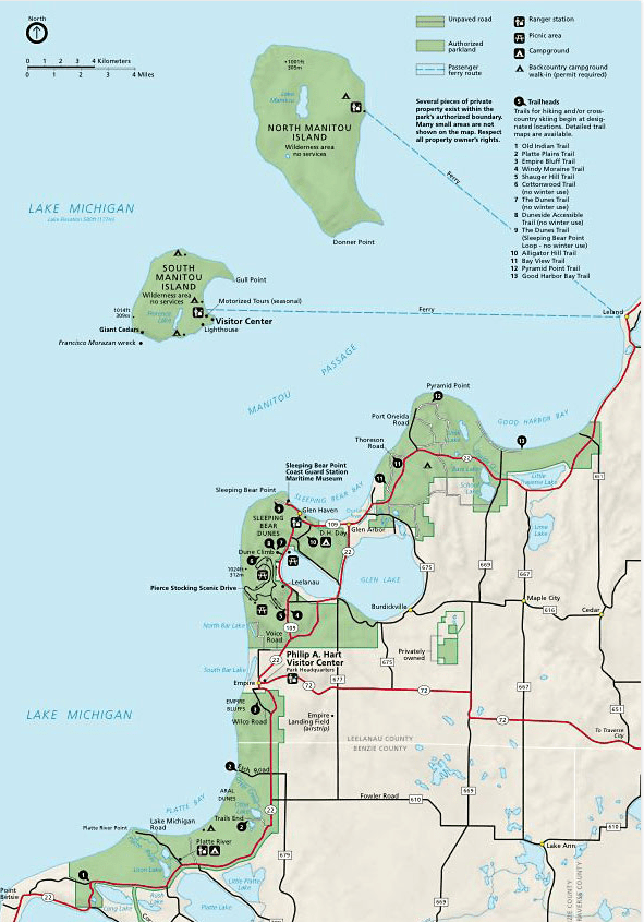
Sleeping Bear Dunes National Lakeshore is a internationally famous park and draws visitors from all over the world. The park has thirty five miles of Lake Michigan shoreline, including North and South Manitou Islands. Besides the Sleeping Bear Dunes, there are other dunes and bluffs located throughout the park. Forests, lakes, and rivers complete the park’s inventory. The park and adjacent areas get a lot of visitors during the peak summer months. The huge park encompasses 71,187 acres, so there is plenty of room for everyone.
Highway M22 runs through the length of the park and, along with highway M109, provides access to the park’s features. There is private property throughout the park. There are two villages in the park: Empire and Glen Arbor. Cities and villages that are close to the park are Elberta, Frankfort, Benzonia, Beulah, Honor, Maple City, Cedar, and Leland.
I kayaked some of the area’s lakes and rivers during the summer season while on a family vacation with my wife, Colleen, and our son, Trevor. Colleen and Trevor are very understanding when it comes to my passion for kayaking, so I was able to get away occasionally to paddle the scenic waterways of the park. I will give you detailed information and maps of the waters that I visited. I hope that you enjoy paddling them as much as I did!
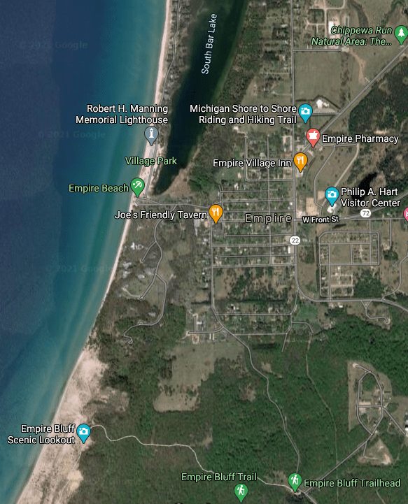
The park Visitor Center is located in the village of Empire. It’s a treasure trove of information and is a good place to start your trip. The friendly park rangers are more than happy to answer any questions that you may have. A park pass purchased at the Visitor Center will give you access to all areas of the park. You are now ready to kayak!
LAKE MICHIGAN, EMPIRE BLUFFS
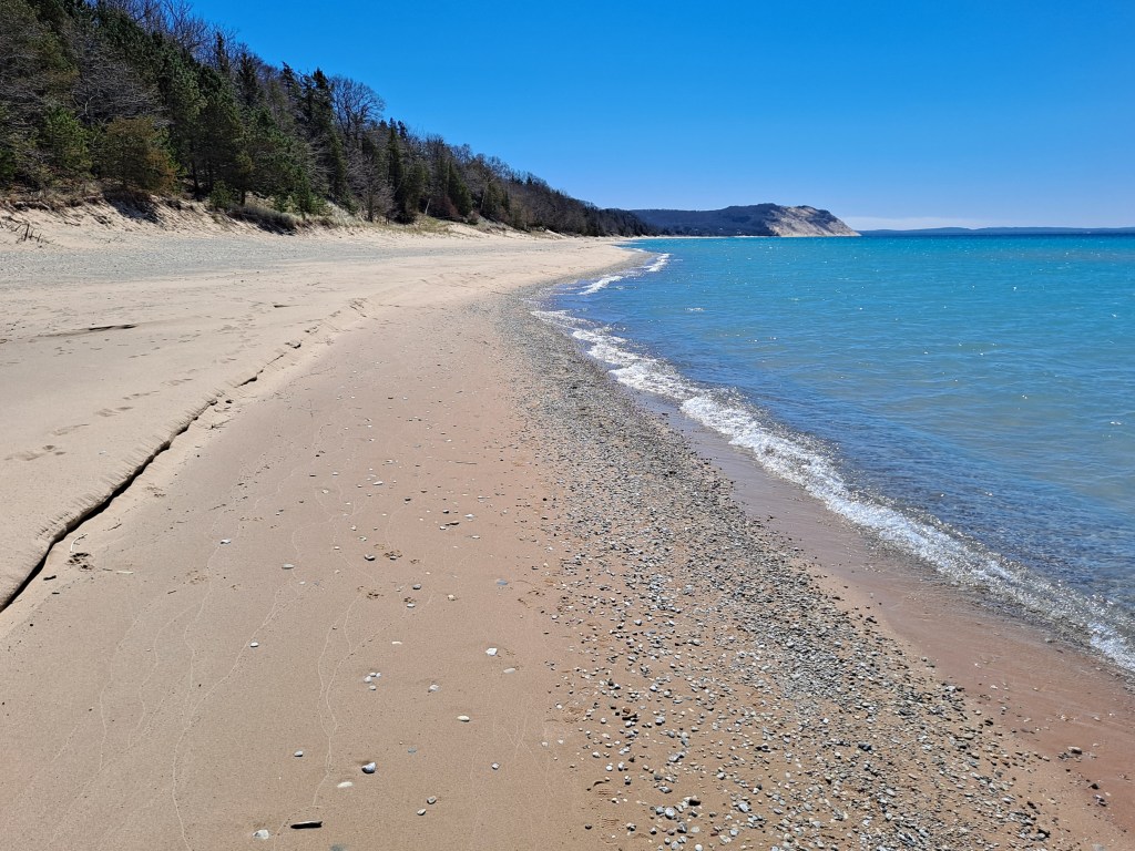
When you think of Sleeping Bear Dunes, your thoughts probably gravitate towards the tall, steep sand bluffs that face the waters of Lake Michigan. Kayaking the Lake Michigan shoreline at the base of these bluffs is an unforgettable experience and the coastline at the Empire Bluffs is a perfect choice.
Empire Bluffs, viewed from the Lake Michigan beach at North Bar Lake
The drawback to kayaking Lake Michigan’s remote shoreline at the bluffs of Sleeping Bear Dunes is the long distance from the nearest lake access. If a storm comes up suddenly and you are paddling many miles from the nearest boat landing, your safety would be compromised. No kayaking adventure is worth your life! There are two lake access sites close to Empire Bluffs, making it the obvious choice.
When kayaking Lake Michigan or any of the other great lakes, get a reliable near-shore marine forecast before you leave. Believe the forecast. If the forecast calls for bad weather, don’t go anyway because the sky “looks good”. Conditions can change rapidly on the big lakes. I can illustrate this fact with a short story. We were fishing in the channel between the piers at a port on southern Lake Michigan. The wind was calm and the seas were running one to two feet. We spotted ominous black clouds on the horizon and they were approaching quickly. We immediately retreated to our car. Within twenty minutes of sighting the storm, the wind was howling and the waves were washing over the piers! I’m not exaggerating. You can imagine what it would be like in a kayak if such a storm came up in a matter of minutes. Don’t tempt fate when kayaking the big lakes! Don’t become a statistic!
Enough about safety. Let’s go kayaking! There is Lake Michigan access in the village of Empire, at the public beach. The beach also has access to South Bar Lake. I didn’t paddle South Bar Lake, but it looked like a interesting lake to explore. Empire Bluffs are south of the beach.
Empire Bluffs, viewed from Empire Beach
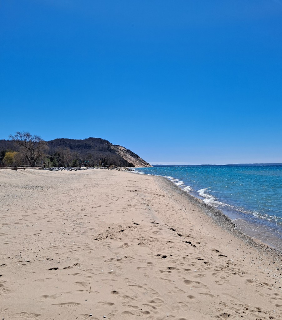
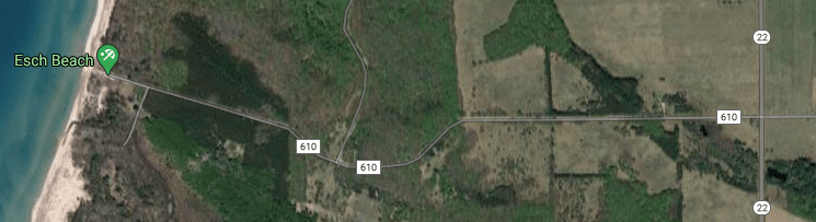
I wanted a little longer trip, so I accessed the lake south of the Empire Bluffs, at the Esch Road Beach. Head west on Esch Road, also called CR610, from highway M22, south of the village of Empire. The beach is at the end of the road. If you don’t have four wheel drive, don’t park in loose sand. It’s a good way to get stuck. This applies to anywhere in the park.
To some kayakers, launching a kayak in Lake Michigan can be a challenge. If you’ve never launched a kayak in surf, then you are in for a surprise. Waves frequently wash over your kayak when they break and sometimes you will get a considerable amount of water in your boat. You can’t paddle your kayak with a bunch of water sloshing around in it. Go back to shore, dump the water out, and try again. I got lucky and made it on my second try! This is an instance where a spray skirt would come in handy. Unfortunately, I didn’t have one. Another strategy is getting in your kayak beyond the surf, in deeper water. That’s not easy, but it is an option. Don’t be discouraged. Once you are successfully in your kayak and paddling, you’ll forget all about it.
My experience paddling Empire Bluffs was fantastic! Sun, cloudless sky, and light winds were the order of the day. Seas were one to two feet with light surf close to shore. As you head toward the bluffs, keep your kayak out from shore, beyond the breakers. Paddling swells is much easier and safer than negotiating breaking waves. While I paddled the bluffs, the swells increased in height from two feet to four feet. The increase in the size of the swells did not make paddling more difficult. With a little experience, you’ll be able to match the rhythm of your paddling to the rhythm of the waves.
Paddling the coastline below the towering Empire Bluffs is a unique experience. You can fully appreciate their size and beauty from a boat. To the north, unless it’s hazy or foggy, you can see the Sleeping Bear Bluffs off in the distance. To the south, Platte River Point juts out into the lake. You cannot replicate this scenery anywhere else! Enjoy!
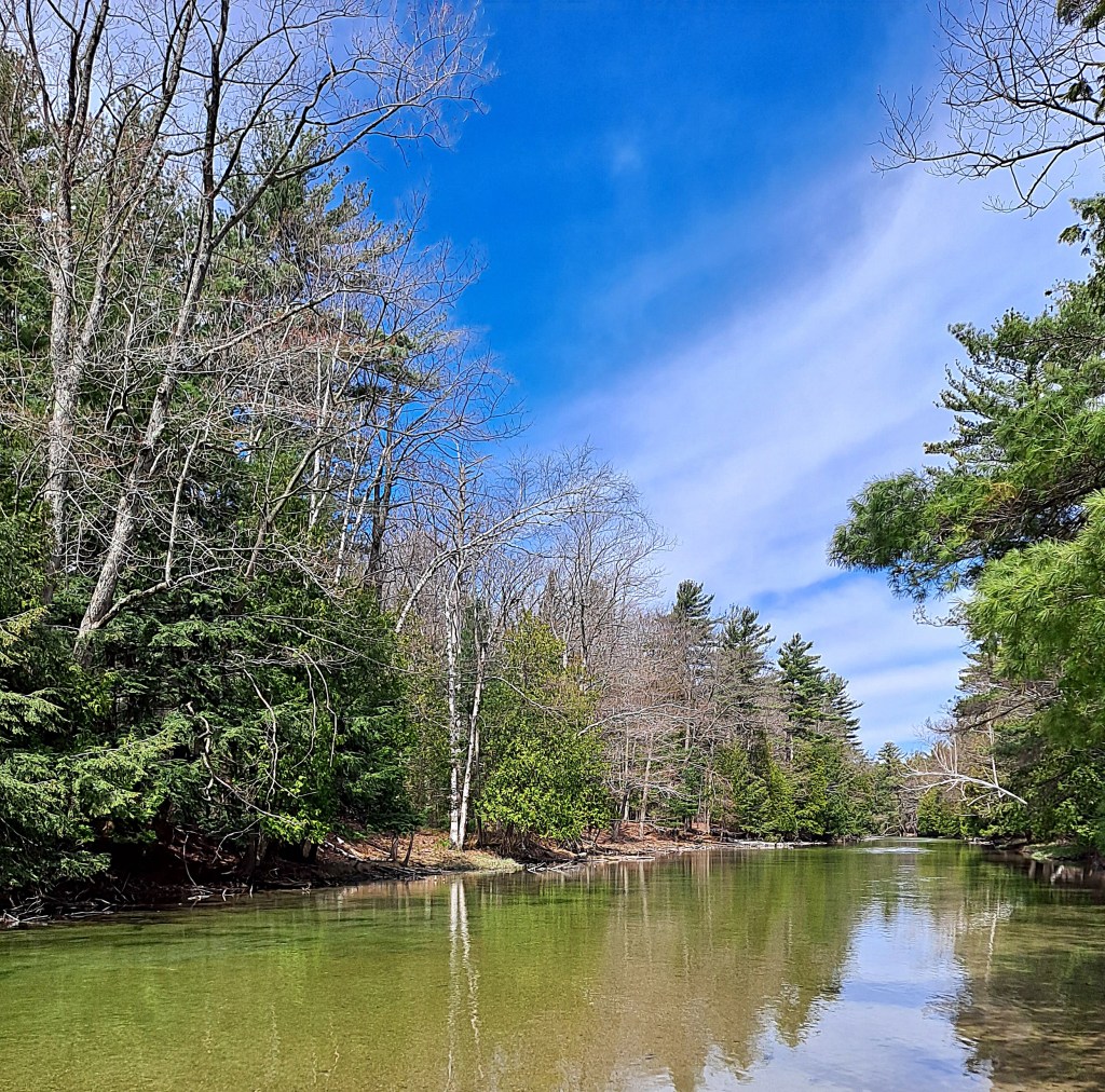
PLATTE RIVER, HIGHWAY M22 TO LAKE MICHIGAN
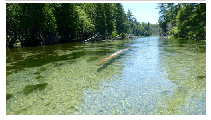
This stretch of the Platte River is a relatively short trip, but it is a worthwhile destination. The river is shallow, crystal clear, and has a mostly sand bottom with some sections of gravel and rock. The current is moderate. It is suitable for kayakers of all skill levels. The banks of the river are wooded and they transition to low dunes close to Lake Michigan. Lake Michigan Road, also known as CR708, runs roughly parallel to the river from highway M22 to the boat landing and a parking area at Lake Michigan. The road is located on the north side of the river.
This stretch of the Platte River can be crowded with boaters and tubers during the peak months of the summer season. To avoid the crowds, go early in the morning. Before Memorial Day and after Labor Day are other viable options.
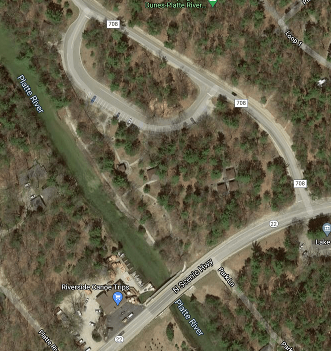
There is a canoe/kayak livery at the M22 bridge over the river. If you rent a watercraft from the livery, you can use their launch site.
There is a public access site on Lake Michigan Road (CR708). The entrance is 350 feet northwest of M22.
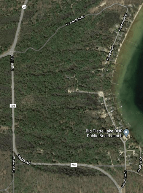
For a little longer trip, there is access at the northwest corner of Big Platte Lake. Head south on Platte Road (CR706) from M22. At the end of the second curve in the road, take Arborvitae Drive north to the MDNR boat launch. The river flows out of Platte Lake at the north end of the lake.
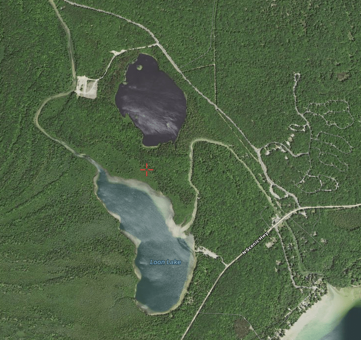
From M22, the river flows in a relatively straight line. At the first major bend in the river, there is a creek that connects to Mud Lake. Sometimes, the creek is navigable. It might be blocked by fallen trees. I’ve paddled it and it’s worth checking out.
In this satellite photo, Mud Lake is north of Loon Lake. The cleared area west of Mud Lake is the weir area. Big Platte Lake is in the lower right corner of the photo. Lake Michigan Drive (CR708) is northwest of the river and northwest of Mud Lake. M22 is also known as North Scenic Highway.
Downstream from the creek to Mud Lake, the Platte flows into the middle of the east side of Loon Lake. The lake is surrounded by national lakeshore parkland. There is a boat ramp on the lake. The entrance to this access site is on M22, a quarter mile south of the M22 bridge over the river. Loon Lake is deep with a near shore drop-off all the way around the lake. The river flows out of the lake at its north corner.
Downstream from Loon Lake, there is a trout and salmon weir across the river with a gate in the middle for paddlers. The gate is open most of the year. At certain times, in the fall season, the gate is closed and the weir must be portaged.
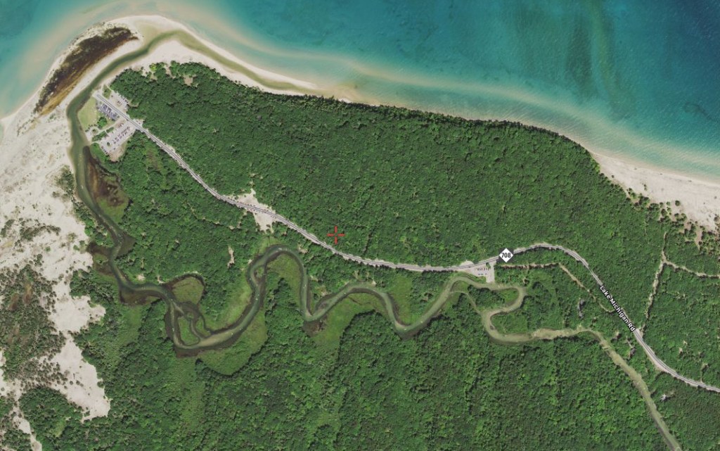
Next to the CR708 sign on the map is the El Dorado Landing. This spot is popular as a launch site for people who travel the river in tubes.
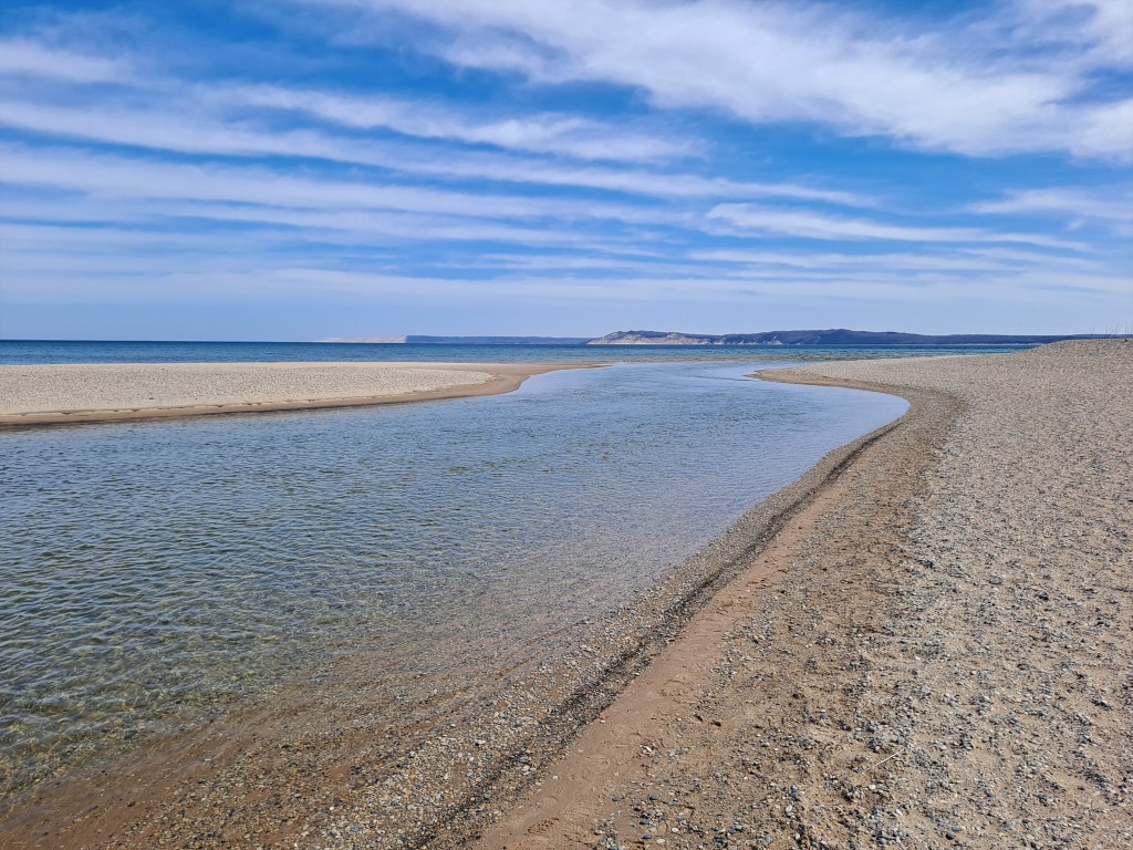
The river twists and turns as it meanders toward Lake Michigan. There are some shallow spots at the lower end of the river. The river flows into Lake Michigan’s Platte Bay at Platte River Point.
The boat landing and the parking area are just upstream from the mouth of the Platte. You can paddle out into Lake Michigan from the river if conditions are safe. The mouth of the river is a nice spot for a extended stay. The Sleeping Bear Bluffs and the Empire Bluffs are easily visible. I have been known to wade upstream from the landing with a sit-up air mattress, enjoying a cold beer while drifting back down the river to Lake Michigan! I’m sure you’ll have fun on this scenic stretch of the Platte River!
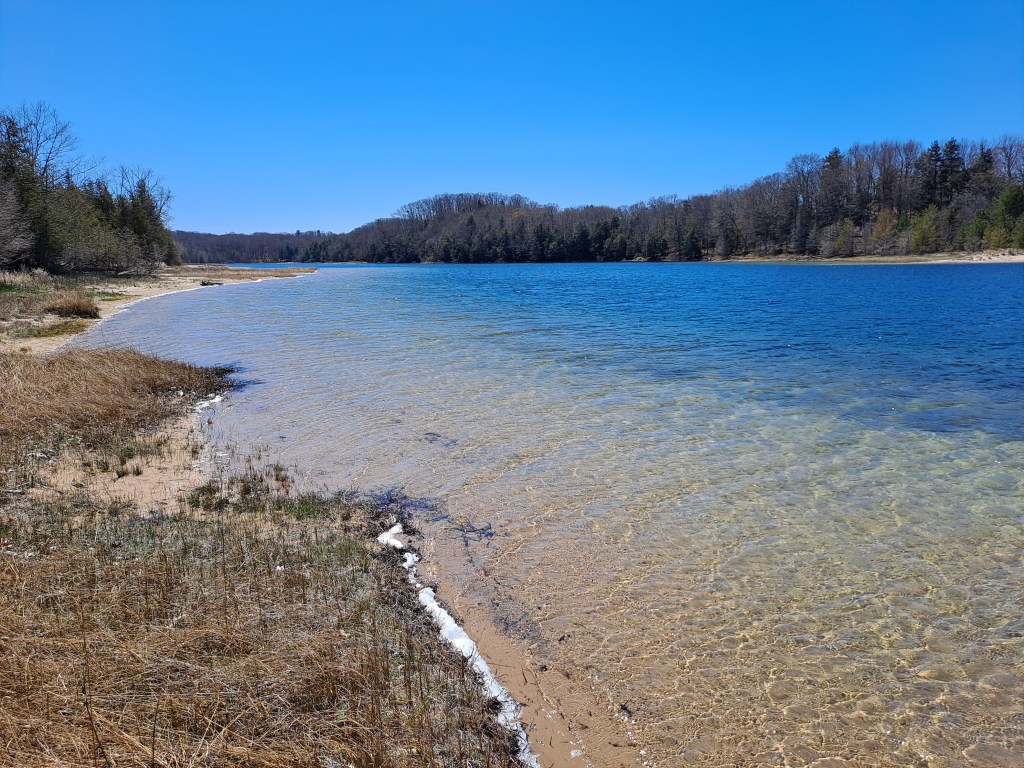
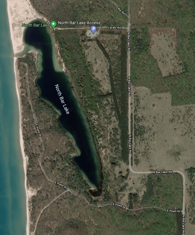
NORTH BAR LAKE
North Bar Lake lies just north of the village of Empire. The long, narrow lake was once part of a bay on Lake Michigan. The lake was formed when water ponded behind a sand bar. The sand bar is now a long, narrow, wooded piece of land that separates North Bar Lake from Lake Michigan. At the northwest end of the lake, there are low sand dunes with a channel leading to Lake Michigan. Whether or not the channel actually connects to the Big Lake depends on water levels.
From highway M22, north of Empire, head west on Voice Road. Turn north on North Bar Lake Road. This road curves west, then curves back north. Next, go west on Larahr Road. It will take you to a paved parking lot with a vault toilet.
A footpath at the northwest corner of the parking lot leads to the lake and the boat access. The footpath continues around the north end of the lake to the Lake Michigan beach. The trail to the lake is five hundred feet long and not very many people are willing to carry a boat that far. I originally balked at the long carry, but quitting is for sissies.
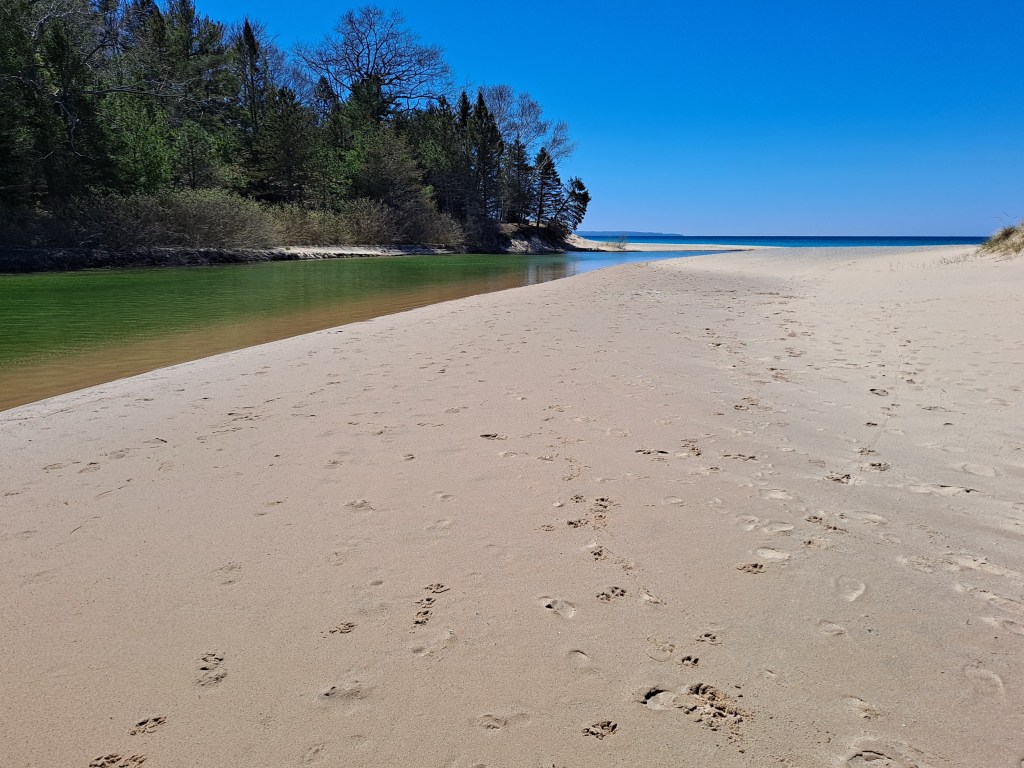
When I arrived at the lake with my boat, I took a quick swim to cool off and began my voyage. I paddled around the north end of the lake. The shifting sand dunes along this shore have created a steep drop-off right at the water’s edge. I continued south along the west shore and turned into the shallow channel to Lake Michigan. This was a year of low water levels, so the channel ended just shy of Lake Michigan. It’s a very short portage to the Big Lake.
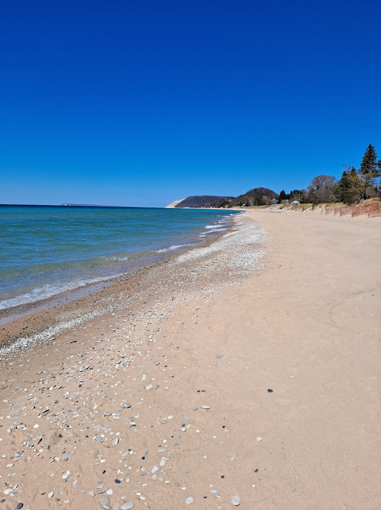
I didn’t make the portage, choosing to spend my time on North Bar Lake instead. I did beach my kayak at the end of the channel and walked the few dozen steps to the shoreline of Lake Michigan to check out the scenery. To the north, the bluffs of the Sleeping Bear Dunes rise up from the water’s edge. To the south, the Empire Bluffs are equally impressive. What a cool spot!
Shauger Hill and Sleeping Bear Bluffs
I returned to my kayak and paddled the channel back to North Bar Lake, heading south along the west side of the lake.
The rest of the lakeshore is different than the low dunes at the north end of the lake. The coastline is wooded and pleasing to the eye. There is a series of points on the west side of the lake, south of the Lake Michigan channel. On the east side of the lake, I noticed many tiny streams flowing into the lake and I could hear the sound of running water coming from the woods. There must be many springs along this shore.
This lake is beautiful and I lingered on the water for quite a while. I was not looking forward to the long carry back to the parking lot. My kayak was not going to carry itself. On the way back, the trail seemed twice as long. Even though I complain about the carry, I still enjoyed every minute of this adventure. The extra effort it took to get to and from the lake was worth it! North Bar Lake is off the beaten path and is a gem in the Sleeping Bear Dunes National Lakeshore. I hope you have a chance to paddle its waters!
When you return to the corner of Larahr Road and North Bar Lake Road, instead of heading south on North Bar Lake Road, turn north on Shauger Hill Road.
This scenic seasonal road meanders up and over Shauger Hill. It emerges from the woods at highway M109, 700 feet south of the entrance to Pierce-Stocking Scenic Drive, the highlight of the park.
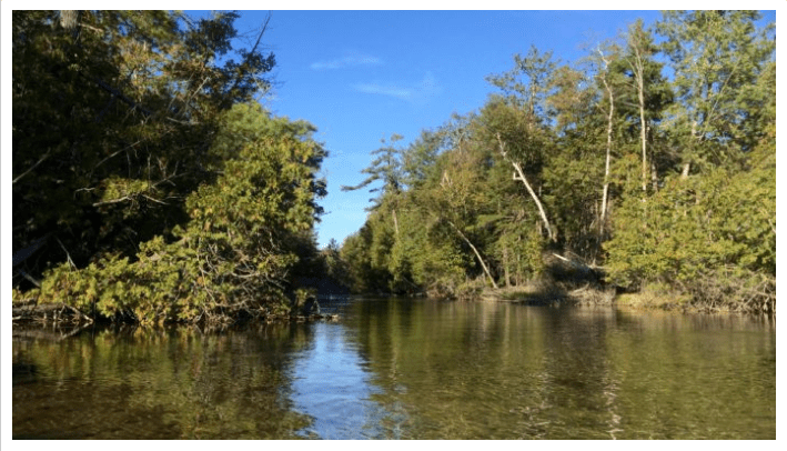
CRYSTAL RIVER, FISHER ROAD TO GLEN ARBOR
The Crystal River begins as the outlet from Little Fisher Lake in Leelanau County. Little Fisher Lake is connected to Fisher Lake and Glen Lake. The river flows in a series of U-shaped loops to Sleeping Bear Bay in Lake Michigan. The Crystal River is shallow and the water is exceptionally clear. The current is slow to moderate and the bottom is mostly sand with some gravel and rock. The banks of the river are wooded. There are two portages with a optional third portage. Kayakers of all skill levels will enjoy this river.
Colleen and Trevor joined me on this Crystal River adventure. I had my own kayak and we rented kayaks for Colleen and Trevor from an outfitter in the village of Glen Arbor. The outfitter provided transportation for us and our kayaks to the launch site.
When you begin paddling, keep an eye on the water depth. In some places, the river may be too shallow to float you and your kayak. You will have to wade your boat to deeper water.
We began our four and a half mile trip at a boat landing on Fisher Lake Road, south of Crystal View Road (CR675). The landing is on the north side of the river, on the west side of the road. Shortly after launching, we encountered our first portage at a small dam. The portage was short and easy.
Below the dam, we paddled through several of the U-shaped loops and arrived at Crystal View Road (CR675). The river flows under the road through three culverts. I recommend taking the far left culvert. The trip through the culvert is a short, fast, downhill run and the river makes a hard left turn as soon as you exit the culvert. Running the big pipe was great fun and we made it through without incident. If you are less adventurous, there is the optional portage on the left bank of the river with easy river access on the other side of the road.
After the culverts, the river heads north through another series of U-shaped loops and ends up back at Crystal View Road (CR675). This is the last portage of the trip.
Downstream from the Crystal View Road portage, the river travels in a relatively straight line southwest for six tenths of a mile. It then makes a one hundred eighty degree turn back northeast. We ended our trip just downstream from the bend, on the north side of the river, at our outfitter’s boat landing in Glen Arbor.
Our trip down the scenic Crystal River was a memorable one and we hope to do it again soon!
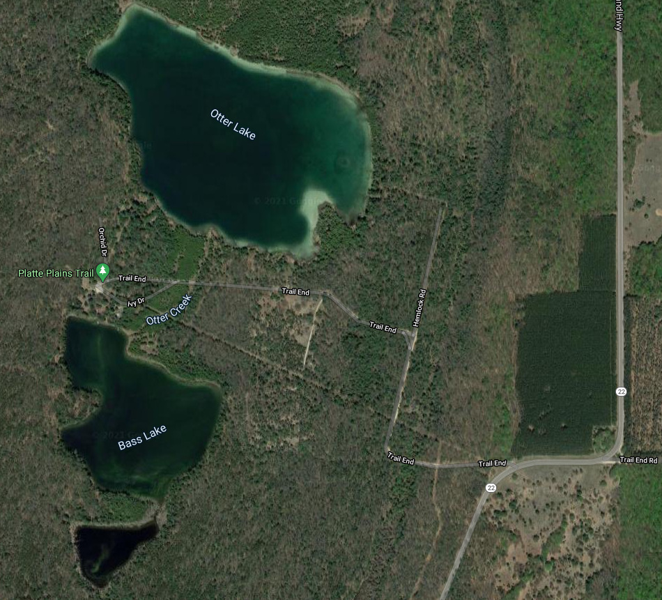
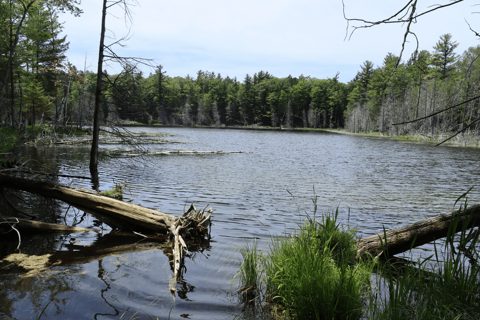
DEER, BASS, and OTTER LAKES
These three lakes are nestled back in the forest, west of highway M22, between the village of Empire and the Platte River. They can be accessed by heading west on Trails End Road from M22. Each lake is fairly deep with a near shore drop-off. Otter Creek flows north from Deer Lake to Bass Lake, then north from Bass Lake to Otter Lake, and, finally, northwest from Otter Lake to Lake Michigan. Trails End Road crosses over Otter Creek between Bass and Otter Lakes. I don’t think the lakes are very well known. I paddled the lakes during summer and my kayak was the only boat on the lakes. Due to the small size of the lakes, you can easily navigate them in an afternoon, without hurrying.
Otter Lake is the largest and the northern-most of the three lakes. Otter creek flows north from Bass Lake to the south shore of Otter Lake. The creek is not navigable between the two lakes. Otter Creek exits the north side of Otter Lake and it is not navigable there either. The entrance to the lake access is on the north side of Trails End Road, three hundred feet east of Otter Creek. The shoreline is muddy. There are about five private residences on the lake, but I’ve never seen any signs of activity.
When I was paddling along the north shore of the lake, I spotted small animals swimming toward me from the center of the lake. Our courses were going to intersect, so I stopped paddling and sat perfectly still. When they got closer, I could see that they were a family of otters! They stopped about fifteen feet away from my kayak, looked at me, and voiced their displeasure at my presence. The otters soon got tired of me, swam to shore, and disappeared into a cedar swamp. It was an experience that I’ll never forget!
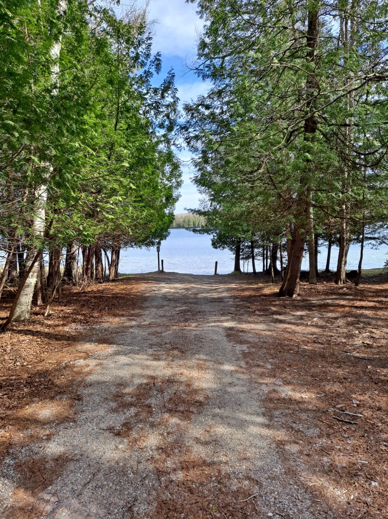
Bass Lake lies between Otter Lake and Deer Lake. The lake can be accessed from a parking lot at the end of Trails End Road. It’s a short carry from the lot to the water’s edge. There is a nice dock at the launch site. The site is another one of my legendary swimming holes. The waters of Bass Lake are very clear and the forested shores are picture perfect.
Deer Lake is the smallest and the southern-most of the three lakes. Deer Lake can only be accessed from Bass Lake. Unfortunately, that access is difficult. Otter Creek flows one hundred sixty feet from Deer Lake to Bass Lake and it is blocked by a beaver dam. The shoreline of the creek and the area around the dam is swampy and has fallen trees scattered about. The shoreline around the lake has been flooded by the beavers and is lined with dead trees. I could not find a decent place to portage.
Deer Lake is scenic and beautiful, but you have to be extremely determined to kayak it.
If you visit the Sleeping Bear Dunes National Lakeshore, be sure to include Deer, Bass, and Otter Lakes in your kayaking itinerary. These scenic lakes are sure to please!