For those of you who are not familiar with the northern lower peninsula of Michigan, Ludington is a port on the shores of Lake Michigan, between Big Sable Point and Little Sable Point, north of the city of Muskegon and south of the city of Manistee. Two major highways intersect at Ludington: US10 and US31. Ludington is a tourist town and has many options for camping, lodging, food, and shopping. It is the home port for the S.S. Badger of the Lake Michigan Car Ferry line. The Pere Marquette River, the Sable River, and the Lincoln River flow into Lake Michigan in the Ludington area.
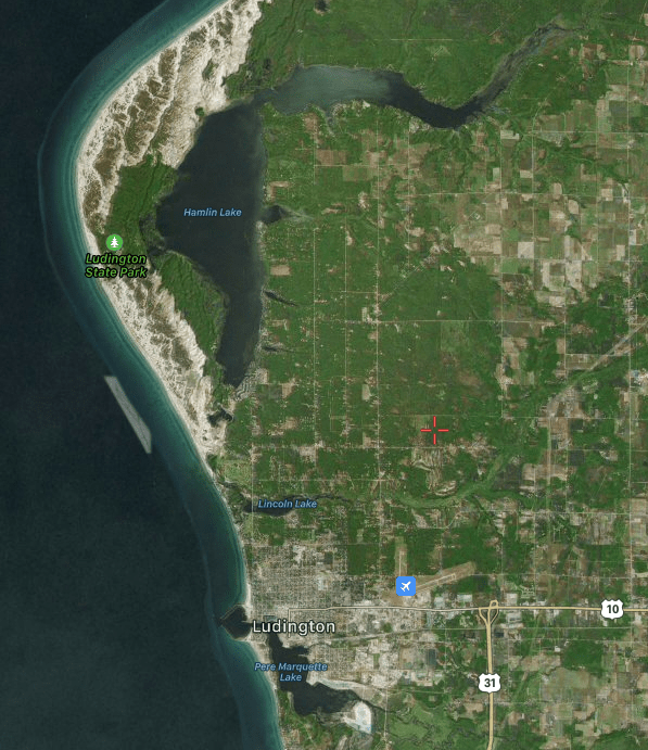
The highlight of the area for kayakers is a very short drive north of Ludington: Hamlin Lake and Ludington State Park. Hamlin Lake consists of two distinct bodies of water that are connected at the “Narrows”: Upper Hamlin and Lower Hamlin. Hamlin Lake is an impoundment of the Sable River, which flows into the east end of Upper Hamlin. The dam is located roughly in the middle of the west shore of Lower Hamlin, in the state park. Below the dam, the Sable River continues through the state park and into Lake Michigan. At the northwest corner of Lower Hamlin, sand dunes rise up from the water’s edge and stretch for a mile and a half along the shore. These dunes can be seen from all over the lake. Hamlin Lake and the connecting waters will keep kayakers busy for several days. Because Hamlin Lake is an impoundment of a river, kayakers should beware of submerged stumps and trees that lie just below the surface of the water. Because of the large size of Hamlin Lake, winds can whip up large waves up to three feet in height. When these conditions exist or are forecast, exercise good judgement when attempting a trip that includes a open water passage. The waters in the Ludington area can be quite busy in the peak summer months. My Ludington kayaking trips have all been in early September and I rarely see other kayakers. Specific information on the waters of the Ludington area that I have kayaked is next. I encourage you to paddle the scenic waterways of Mason County. You will be glad that you did!
WEST SIDE LOWER HAMLIN LAKE
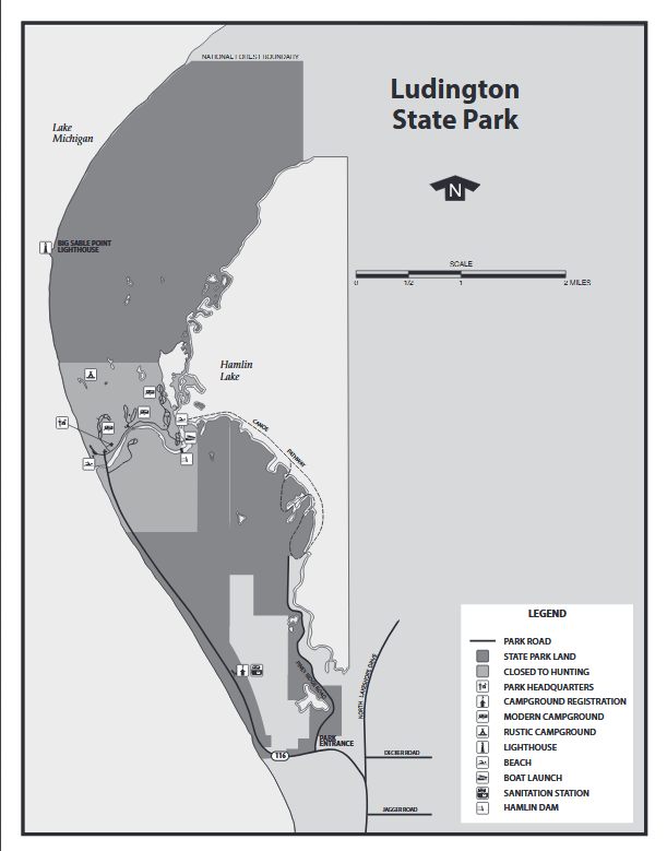
Use the Ludington State Park boat launch site for all kayaking trips on the west side of Lower Hamlin Lake. This includes Lost Lake and surrounding waters, and the Ludington Canoe Pathway. Take highway M116 north from Ludington to the state park. Follow the park signs to the Hamlin Lake boat access site. It is right next to the Hamlin beach and beach house. You can rent watercraft at the beach house. Let’s go kayaking!
LUDINGTON CANOE TRAIL
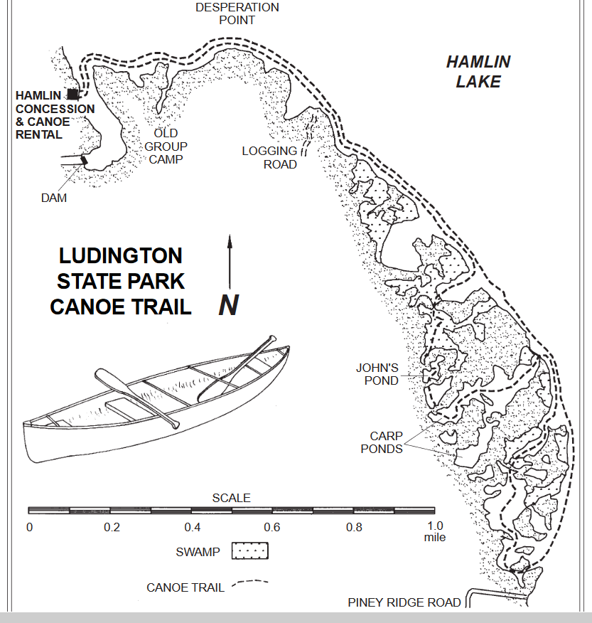
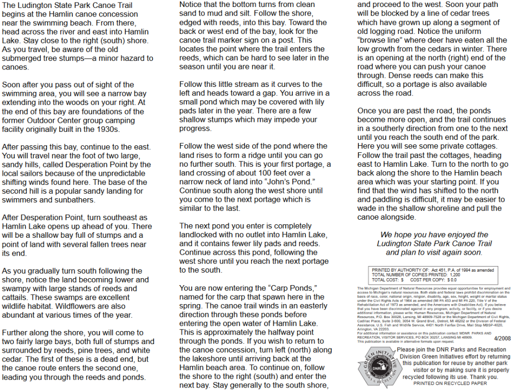
Following this beautiful, scenic water trail will take you through a series of bays, coves, and ponds that are west of the main basin of Lower Hamlin Lake. You will enjoy heavily wooded shorelines, wetlands, and abundant wildlife on this trip. This voyage is for paddlers of all skill levels.
After launching your kayak at the state park boat landing, head east across the wide channel and follow the shoreline north. Continue following the shoreline as it curves east. You will see the open waters of the main basin up ahead. When you reach the main basin, follow the shoreline south to the first of two inland portions of the water trail. Between the two portions, the water trail briefly returns to the main basin of the lake. The trail is marked by sign posts. I recommend that you take your time and explore the different coves, bayous, and ponds as you navigate the two inland portions of the water trail.
The two inland portions have five portages. Four of the five portages are marked by signs and are not hard to find. These portages are easy and short. The longest is only about thirty feet. There is a short dock at each end of four of the portages. There is a portage at the end of the first inland portion, where the water trail returns to the main basin of the lake. The last time I kayaked the water trail, this portage was hard to find, hidden by thick cattails.
After returning to the main basin from the first inland portion, follow the shoreline south to the second inland portion of the water trail, which is marked by signposts. There are more coves and ponds to explore.
A bayou at the south end of the second inland portion of the water pathway will take you back to the main basin of the lake. There are a few homes and cottages on this bayou as you get close to the lake. Once you emerge from the bayou and you are on the main basin, follow the shoreline north to the boat landing.
What you can expect as you paddle the two inland portions of the water trail: The water is shallow for the most part. In a few places, you may have to search for water that is deep enough to float your boat. The water alongside some of the portage docks is very shallow. You may have a hard time getting to or from these docks. Occasionally, aquatic vegetation can be thick and difficult to paddle through. Submerged stumps and trees are waiting for the unsuspecting paddler.
If the wind is from the north, northeast, east, or southeast, the portion of the water trail that follows the shoreline of the main basin of Hamlin Lake might be difficult to paddle due to large waves.
This guide has additional information in detail that will help you enjoy the water trail. I have found the guide to have a few inaccuracies, but they are very few in number. For the most part, the guide is correct:
Have fun and be safe!
LOST LAKE AND SURROUNDING WATERS
Kayaking some portions of this area will require paddling the main basin of Lower Hamlin Lake. You may be exposed to wind and large waves. If these conditions exceed your capability, change your itinerary to protected waters, out of the wind.
This part of Lower Hamlin is known for its exceptional scenic beauty. There are islands, coves, and bayous to explore. It may take you more than one trip to kayak this portion of the lake at a leisurely pace.
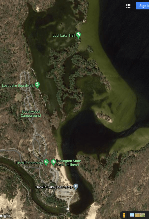
South of the boat ramp, the wide channel curves to the southwest and the Hamlin Dam spans the channel. At the curve, there is a sand dune at the water’s edge that makes for a dandy swimming spot.
North of the boat landing, the wide channel empties into a large bay with an island on the east end. The main basin of Lower Hamlin is on the east side of this island. On the south side of the bay, there is a small cove and a long narrow bayou to explore.
On the northwest end of the bay, there is a wooden foot bridge over the south channel to Lost Lake. Lining the west shore of Lost Lake is a boardwalk and one of three park campgrounds. There is a tall sand hill on the north end of the lake. A second wooden foot bridge spans the north channel to Lost Lake. On the east side of Lost Lake, the land between the two foot bridges is a large, spider-like island. I recommend paddling all the way around this island. Explore every nook and cranny of the island’s shore and you will be rewarded with scenic views of its bays, hidden coves, passages, and smaller islands.
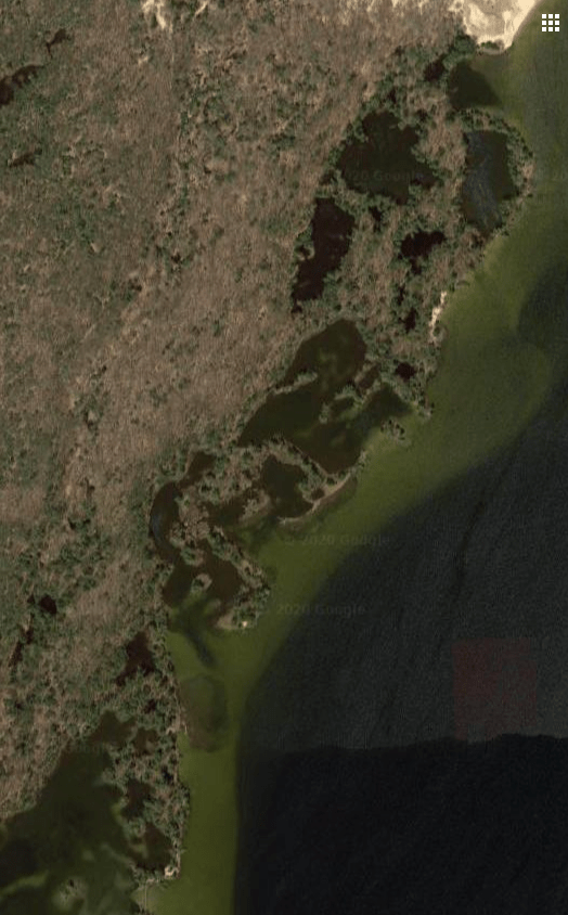
The Lost Lake north channel is at the bottom left of the satellite photo and the beginning of the sand dunes is at the top right.
Exiting Lost Lake at the north channel will take you to the Lower Hamlin Lake main basin. Follow the shoreline north to get to the sand dunes. On the way, there are several coves to explore. Parts or all of some of these coves are choked with reeds and other aquatic vegetation, making them difficult to paddle. The northern-most cove is right next to the dunes and is easy to paddle. There is a hiking shelter on the shore at the west end of the cove. North of the cove, you can paddle the sand dune shoreline to your heart’s content. The dune coastline is a great place to stop and take a break or a extended stay before heading back to the boat landing.
EAST SHORE LOWER HAMLIN LAKE
This trip is for kayakers who enjoy paddling lakes with developed coastlines. The shores of this portion of Lower Hamlin are lined with homes, cottages, and resorts. The coastline is relatively straight and is punctuated by three bayous: North, Middle, and South. Each bayou is fed by a small stream on its east end. The South and Middle Bayous are fully developed, while the North Bayou is sparsely developed.
This is usually the windy side of the lake, so large waves are a frequent occurrence. If you are unsure of your ability to handle rough water, wait for calmer conditions.
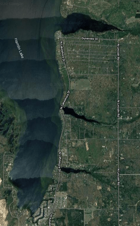
Head north on highway M116 from Ludington. When the highway curves to the west, continue straight, north, on Lakeshore Drive. There are two public boat landings on this side of Lower Hamlin. One landing is south of the mouth of the North Bayou. Turn west at the intersection of Lakeshore Drive and Duneview Avenue. The landing is straight ahead. I chose to use a boat launch that is on the South Bayou simply because I thought it was more scenic. This landing is on the east side of Lakeshore Drive, south of the bridge over the South Bayou Channel.
Kayakers should be especially observant when paddling the North Bayou. It is littered with submerged and emergent trees. The Middle Bayou, South Bayou, and the Hamlin shoreline that is in between the three bayous are mostly free of underwater obstructions.
I paddled the creek that flows into the east end of the Middle Bayou until I was stopped by shallow water. The small stream is a tranquil, shaded, quiet place. I didn’t visit the creeks that feed the other two bayous, but I think that they would be equally pleasant.
I recommend exploring the shorelines of the three bayous and the adjacent main basin coast. I found it picturesque to paddle.
SOUTH SHORE UPPER HAMLIN LAKE
Another developed shoreline that you may find interesting is the west end of the south shore of Upper Hamlin Lake. Take Jebavy Drive north from US10 in Ludington. The road curves northwest and is then called Barnhart Road. Turn north on Beech Lane. Wilson Hill Park and the boat ramp are straight ahead.
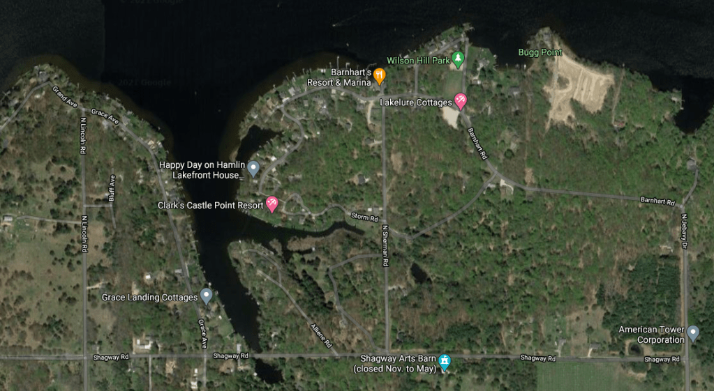
Explore the coastline in both directions from the boat launch. Paddling the shoreline west will take you to one of the features of Upper Hamlin, Indian Pete Bayou. If you liked the east shore of Lower Hamlin, then you will enjoy this portion of Upper Hamlin!
EAST END UPPER HAMLIN LAKE
The east half of the north shore of Upper Hamlin Lake is part of the Huron-Manistee National Forest. The far east end of the upper lake and the Sable River are within the national forest. The east half of the south shore of Upper Hamlin has very little development. The area where the Sable River flows into Upper Hamlin can best be described as a river delta. As a kayaker, these features make the area appealing to me. I hope it appeals to you, too!
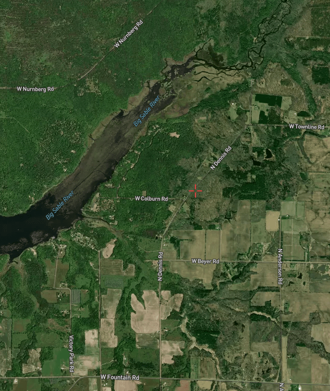
There is a lake access site on the north side of the lake, close to the river delta. Take Nurnberg Road west from Quarterline Road. Turning south on a United States Forest Service road will take you to the boat ramp. I chose to access the lake farther west, on the south shore, at Victory Park. Take Victory Park Road north from Fountain Road and the park is at the end of the road. I picked this boat landing simply because I wanted a longer trip.
The lake in front of the Victory Park landing has occasional areas of sparse reeds. The reed beds gradually grow thicker as you travel east until they cover the whole lake. In places, the reeds are so thick that they are difficult to paddle through. Don’t despair! There is a channel that runs through the reed bed, all the way to the delta! The west end of the channel is about twenty feet wide and gradually narrows to about five feet at its east end. There are some channels that branch off the main channel, but I didn’t explore them.

For many kayakers, paddling through a reed-lined channel for a mile and a half is monotonous and boring. This was my first trip on this part of the lake and I didn’t know what was ahead. A satellite photo doesn’t come close to telling you what to expect. So, for me, this voyage was an adventure. I didn’t find it boring. Besides, how could I get bored with a cooler full of beer in my kayak?
At the east end of the reed-lined channel, the lake transitions to the Sable River Delta and the Sable River. The north and south shores of the lake gradually come together until they almost meet. There is a good-sized wooded island at the beginning of the delta. On the north side of the island, a channel swings by a point on the north shore. This is a great spot to stop and take a break. At the tip of the point, there is an open area at the base of a small hill. The top of the hill offers a nice view and a foot trail leads inland to the end of a USFS trail.
The delta continues upstream from the point and several channels wind their way through cattails, reeds, and grass. Eventually, the channels converge and the river emerges from the delta. I continued paddling up the river. After a while, the current grew stronger and I was making slow headway. It was time for a change in direction. I reluctantly turned around and headed downstream. I took one last break at the point and paddled down the lake to the landing.
It was a exceptional kayaking trip and I was glad that I went. I wouldn’t change a thing. I hope that you get a chance to kayak the east end of Upper Hamlin Lake. It’s a great place to paddle!
PERE MARQUETTE RIVER, CUSTER TO SCOTTVILLE
The lower Pere Marquette River is quite a bit different than the river’s upper reaches. This portion of the river is wider and deeper with slow to moderate current. It feels secluded and remote. The bottom of the river is mostly sand. The river banks are wooded, mostly hardwoods. Some of the land bordering this stretch of the river is Indian tribal land of the Little River Band of the Ottawa nation. This part of the river, from Custer to Scottville, is easy to paddle and is suitable for all kayakers, regardless of skill level.
My wife, Colleen, joined me on this summertime trip. She isn’t too keen on long, extensive voyages, so this shorter adventure was perfect. There were some kayakers, canoeists, and tubers running the river, but we didn’t see them very often. For the most part, we were by ourselves.
I used my own kayak and we rented one for Colleen at an outfitter in Scottville. The outfitter provided transportation for us and both kayaks.
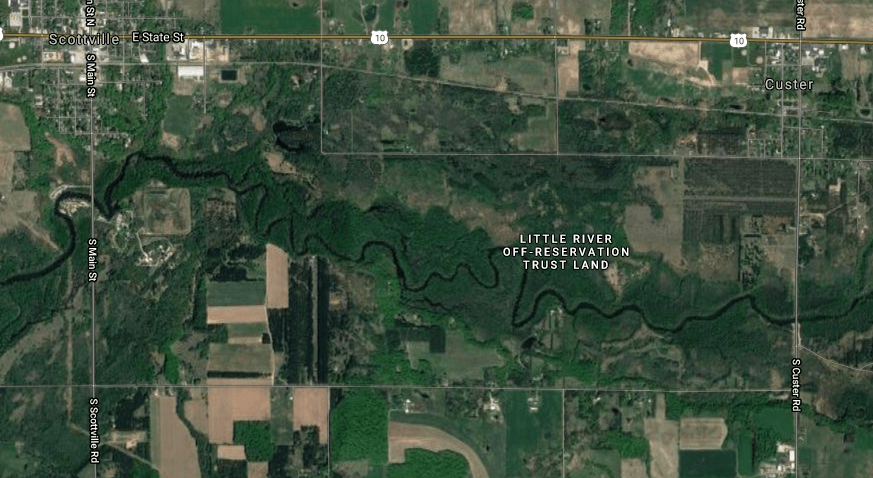
The villages of Scottville and Custer are a short drive east of Ludington on highway US10. We began our trip at the Custer Road bridge, south of the village of Custer. There is river access on the south side of the river, on both sides of the bridge. We ended our trip at a park on Scottville Road, south of the village of Scottville. The entrance to the park is on the west side of the road, on the north side of the river.
We thoroughly enjoyed the scenic beauty of this stretch of the Pere Marquette River. The voyage was perfect for the two of us. We highly recommend this trip and if you go, we know that you won’t be disappointed!
LINCOLN LAKE AND LOWER LINCOLN RIVER
Lincoln Lake and the lower Lincoln River are located north of Ludington on highway M116. You can’t miss it. A bridge carries M116 over Lincoln Lake, dividing it into two parts. Most of the lake is east of the bridge. A much smaller part of Lincoln Lake is west of the bridge. For convenience, I will refer to the two portions of the lake as East Lincoln and West Lincoln. The upper Lincoln River flows into East Lincoln at its east end. The lower Lincoln River flows out of West Lincoln at its northwest corner and continues on to Lake Michigan. The lake access site is on the south shore of East Lincoln, on the east side of M116, right next to the road and Cartier Park.
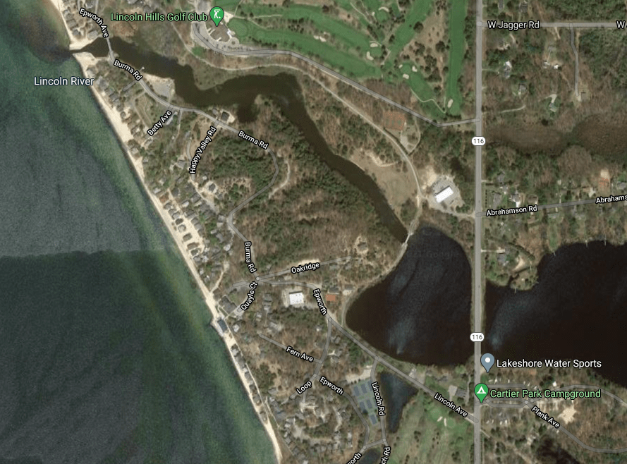
To begin the trip, head west under the M116 bridge into West Lincoln Lake. Straight ahead, west, is the scenic Mount Epworth. The Mount Epworth area is home to the Epworth Assembly, founded in 1894, and Epworth Heights, a resort community.
A bridge at the northwest corner of West Lincoln marks the outlet of the lake and the beginning of the lower river. This newer bridge is the site of a long gone railroad bridge for the Ludington And Northern Railroad. This rail line carried tourists between Ludington and Hamlin Lake until it went out of business in 1919. The rail line was then used by a sand mining company until 1982. The village of Lincoln, settled in 1851, was located roughly north of the bridge. It was once the county seat of Mason County and had a three story boardinghouse, homes, grist mills, sawmills, a courthouse, stores, a dock for ships, and a post office. The mills closed in 1884. The people deserted the village and it became a ghost town. Today, there is no visible sign of the village of Lincoln.
That’s enough history. Let’s get back to kayaking! The bridge at the outlet of West Lincoln Lake has low clearance and some parts of the underside of the bridge have jagged edges that are just waiting to scrape your head.
After emerging from under the bridge, the river passes by the north side of Mount Epworth on its way to Lake Michigan. The current in the lower Lincoln River is slow, almost nonexistent. It is about seven tenths of a mile, by river, from West Lincoln Lake to Lake Michigan.
There is a bridge with plenty of clearance just upstream from Lake Michigan. After the bridge, the river narrows to a walled channel that leads out to the Big Lake.
On the day that I made this voyage, there was a strong wind straight out of the west. A cloudless sky allowed the sun’s rays to reflect off the rough seas and whitecaps on Lake Michigan. The large waves glistened in the sun and were breaking at the end of the channel. Five foot swells rolled up the river, where they gradually dissipated. It was a sight that will last in my memory forever. I paddled into the channel and had a blast riding the swells up and down. The sensation was like riding a small rollercoaster. I didn’t venture out into Lake Michigan. The large breakers at the mouth of the channel and on the Big Lake made conditions unsafe.
After I finished playing on the swells in the channel, I paddled back upstream and across West Lincoln to East Lincoln. I still had energy left, so I toured the south shore of East Lincoln for a little while before heading back to the landing. East Lincoln and the upper Lincoln River seem ripe for further exploration.
I found Lincoln Lake and the lower Lincoln River to be scenic and fun to paddle. If you try it, you’ll leave with a smile on your face!
The Ludington area in western Mason County has a lot to offer kayakers and I hope you follow my advice and visit it soon!
