Wilderness State Park is aptly named. During my voyage, I didn’t see another person or boat. There wasn’t a single sign of human activity. It felt like I was out in the middle of nowhere. It was truly the boonies!
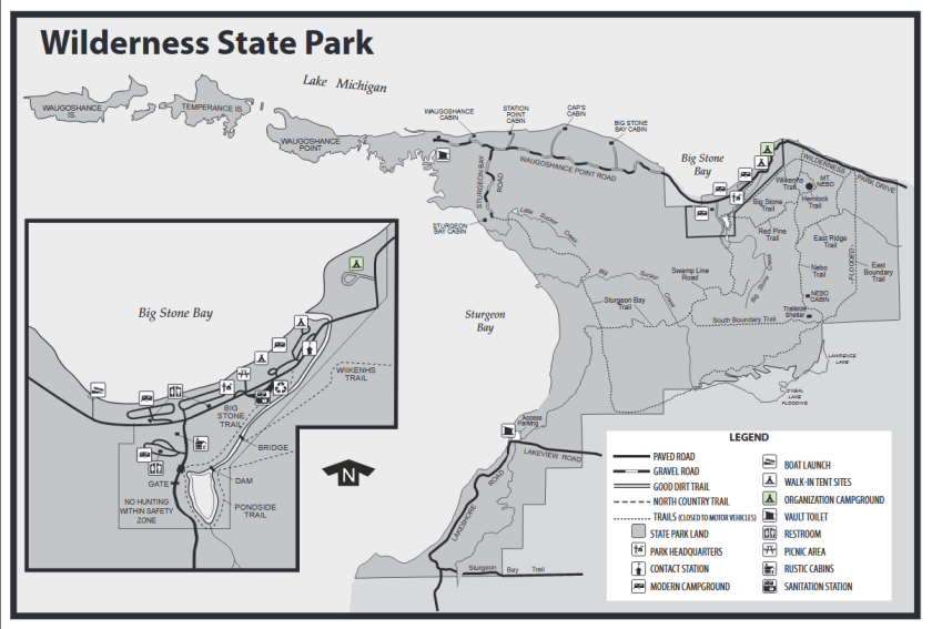
Wilderness State Park encompasses over 8000 acres and includes more than twenty six miles of Lake Michigan shoreline. The part of the park that is most interesting for kayakers is a peninsula called Waugoshance Point. Several islands extend west from the point. Temperance Island is one of the larger islands and is separated from Waugoshance Point by a channel called The Big Cut. Farther west, another large island is Crane Island, also called Waugoshance Island. There are also several other islands. The size and number of islands varies with the Lake Michigan water level. The shorelines of the point and the islands change with the fluctuating water levels. The west end of the Straits Of Mackinaw is north of the park. Sturgeon Bay is south of Waugoshance Point and the islands.
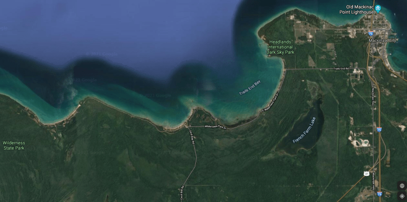
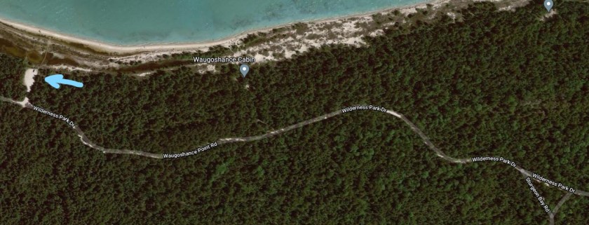
The easiest way to access Wilderness State Park is from Mackinaw City. Head west from Mackinaw City on either Central Avenue or Trails End Road. The two roads intersect Wilderness Park Drive, which will take you to the park. Wilderness Park Drive follows the shore of Lake Michigan, offering views of Trails End Bay, Cecil Bay, and Big Stone Bay. There is a park boat landing on Big Stone Bay. Once inside the park, continue west on Wilderness Park Road, also called Waugoshance Point Road.
If you are paddling the north side of the point, continue west on Waugoshance Point Road, past Sturgeon Bay Road. There is a parking area on the north side of the road. It’s a short carry to the lake.
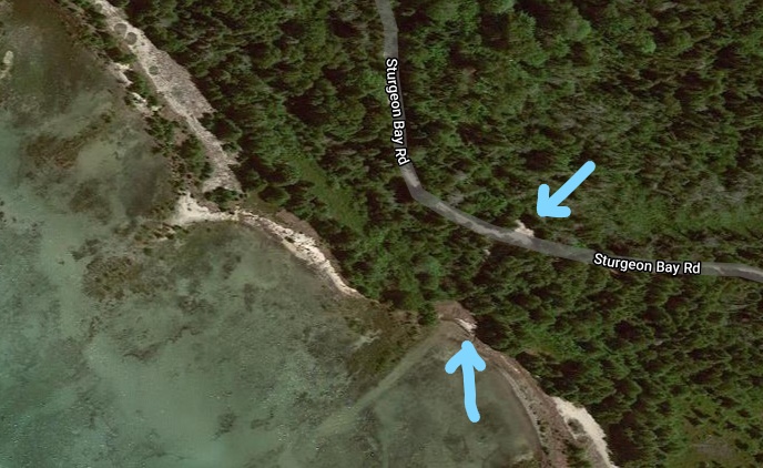
If you are kayaking the south side of the point, head south on Sturgeon Bay Road from Waugoshance Point Road. You will come to a closed gate and a small parking area. A short trail leads to Sturgeon Bay.
Your decision on which side of the point to kayak is dependent on wind speed and, primarily, wind direction. A north wind dictates paddling the south side and a south wind dictates paddling the north side. Obviously, if there is little to no wind, either side of the point is a good choice. I recommend viewing the lake conditions on both sides of the point before making your choice. Also, check a reliable marine weather forecast. A forecasted change in wind direction is a game changer. If you are paddling with the wind and waves, make sure that you are capable of paddling against the wind and waves on your way back. Lake Michigan is nothing to fool around with. Several weeks before I visited these waters, a kayaker paddled out to the point and couldn’t make it back. He had to be rescued. Don’t be that guy!
My trip took place in September of 2019 during high water levels on Lake Michigan. On the day of my voyage, the wind was from the east. After viewing the conditions on each side of the point and rechecking the marine forecast, I decided to kayak Sturgeon Bay. The waters of the Straits of Mackinaw were too rough.
West of the Sturgeon Bay boat landing, there are three unnamed points that I will call East, Middle, and West Points. Goose Bay is between East Point and Middle Point. A unnamed bay that I will call West Bay is between Middle Point and West Point. West of West Point, the shoreline curves northwest towards The Big Cut. The lake bottom is covered with rocks and boulders, some of which lurk just below the surface of the water. Much of the coastline is flooded and is lined with brush and small trees sticking out of the water. In some places, trees stick out of the water far from shore. Dry ground is hard to come by.
I hoped to paddle to the tip of Waugoshance Point and cross The Big Cut to Temperance Island. Since I didn’t know how long it would take to get there, I decided to take a more direct route and do my exploring on the way back. Heading West from the landing, I paddled across the mouth of Goose Bay, from East Point to Middle Point. The east wind was picking up, so I paddled West Bay closer to shore. The waters were somewhat calmer in the bay. When I reached West Point, the wind was considerably stronger. When I left the protected waters of West Bay and rounded West Point, the conditions were much worse than I expected. Large waves and high winds were pushing me westward at a pretty good clip. After traveling a couple hundred feet, I realized that I was going to have a hard time getting back. I reluctantly turned around and faced the wind and the waves. I wasn’t making much forward progress. I picked a reference point on shore and checked its location, relative to my position, from time to time. I was barely moving. I thought about the kayaker that had to be rescued because he couldn’t make it back. I picked up my pace, paddled as hard as I could, and slowly made my way back to West Point. Paddling hard is putting it mildly. Waves broke over my bow many times, but only a couple of them washed into my cockpit. I finally rounded West Point into the less windy waters of West Bay.
Luckily, West Point is one of the few places along the Sturgeon Bay shore of Waugoshance Point that has dry ground. I found a small, narrow sand beach on the thickly wooded point that wasn’t blocked by flooded bushes and trees. I beached my kayak and took a well deserved break. Beer time! My arms were tired from the intense paddling, but it didn’t take long for me to feel rejuvenated. I was glad that I turned around when I did!
It was time to explore! The flooded shorelines of West Bay and Goose Bay have many channels, coves, and ponds to paddle. In some places, you have to travel through flooded brush and small trees to get to some of the waterways. Sometimes, it takes some searching to find a water trail that will take you where you want to go. The water is mostly shallow. These wetlands are a unique feature to explore. I’ve never seen anyplace like it that you can access with a kayak. My explorations of the two bays was in less windy conditions than the offshore waters, so that was a bonus.
On West Bay, I followed channels and ponds as far north as I could paddle. The land surrounding the north end of the waterway was mostly sand covered with dune grass, with a few scrubby trees and bushes scattered about. I think it’s called a interdunal wetland. I could hear the unmistakable sound of pounding surf. I beached my kayak and walked north a hundred feet over a low sand dune. Lake Michigan was at my feet! I was on the north side of Waugoshance Point! A beautiful sand beach extended in both directions as far as I could see. Under a cloudless sky, white-capped waves glistened in the sun. Across the Straits of Mackinaw, the outline of the upper peninsula was visible on the horizon. There wasn’t a person in sight. When you kayak, you can find scenic areas that most people will never see.
I made my way back to West Bay and continued east to Goose Bay, exploring as I went. By the time I finished touring the backwaters of Goose Bay, it was getting late in the afternoon. I paddled back to the boat landing, ending a perfect day on the water.
When you visit Wilderness State Park, the waters of Waugoshance Point may look entirely different than the way it looked when I was there, due to the varying water levels of Lake Michigan. The elevation of most of Waugoshance Point is only slightly higher than the water level of the Big Lake. Some of the islands that are visible during low water will disappear during high water. Shorelines will change from year to year. If the water levels drop, some of the areas that I paddled might be dry land. In the end, it doesn’t really matter if the water levels of Lake Michigan are high or low. Waugoshance Point will always be a great place to kayak!
